2002 Kalehe earthquake
 | |
| Date | October 24, 2002 |
|---|---|
| Magnitude | Mw 6.2 |
| Depth | 10 km |
| Epicenter | 1°54′18″S 29°00′47″E / 1.905°S 29.013°ECoordinates: 1°54′18″S 29°00′47″E / 1.905°S 29.013°E |
| Casualties | 2 |
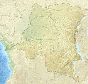
The 2002 Kalehe earthquake occurred on October 24 at 06:08 UTC. This earthquake had a magnitude Mw 6.2, and the epicenter was located in Democratic Republic of the Congo, near Lake Kivu. Two people were reported dead. Building damage was reported in Goma, Lwiro, Kalehe, and Mugeri.[1][2] The seismicity, volcanism, and uplift in the basin of Lake Kivu delimits the rift of a tectonic plate.[3] Lake Kivu belongs to the western branch of the East African Rift System (EARS). The western branch is usually divided into several segments, and Lake Kivu belongs to the northern segment.[4]
References
- ↑ http://earthquake.usgs.gov/earthquakes/eqinthenews/2002/uskrbv/
- ↑ "Natural Disasters and Hazards in the Lake Kivu Basin, Western Rift Valley of Africa" by D. M. Wafula, M. Yalire, M. Kasereka, M. Ciraba, M. Kwetuenda, and H. Hamaguchi
- ↑ http://adsabs.harvard.edu/abs/2010EGUGA..12.6361B
- ↑ https://netfiles.uiuc.edu/wpchen/shared/Reprints_Wang-Ping_CHEN/74_YangChenE_AfricaRiftJelleySandwichRheology.JGR.10.pdf
This article is issued from Wikipedia - version of the 4/17/2016. The text is available under the Creative Commons Attribution/Share Alike but additional terms may apply for the media files.