A46 autoroute
_Route_marker.gif)
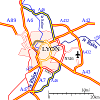
The A46 autoroute is a 47.6 kilometres (29.6 mi) long highway in central France. It connects the town of Givors to Anse and eastern Lyon. It was completed in 1992.
Characteristics
- 2x2 lanes (2X3 lanes at Rillieux-la-Pape)
- 65 km long
- A radar speed trap has been installed at Rillieux-la-Pape (southbound). Speed limit 90 km/h.
History
- 1992 : Opening of the A46 and the RN346.
- 2007 : Opening of the third lane between Genay and the Mionnay Service Area.
Since 2002, there have been further attempts to prohibit heavy traffic over 7.5 tons in Lyon and divert them onto this motorway-by-pass. This is controversial because it generates extra journey times distances travelled.
Junctions
Junction Autoroute A7 to A46 near Lyon
 Exchange A6-A46 Junction with the A6 to Villefranche, Dijon and Paris (north) and Lyon (south)
 01 (Quincieux) Towns served: Quincieux
- 02 (Genay-Trévoux) Towns served: Genay/Trévoux
 Péage de Genay
 Service Area: Mionnay
- 03 (Les Echets) Towns served: Les Echets, Bourg-en-Bresse via RN83.
- 04 (Sathonay) Towns served: Sathonay
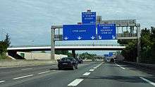
- Junction A46-A42-N346 Junction with A42 to Bourg-en-Bresse and Geneva the A46 becomes the N346 on a bridge over the River Rhone.
- Junction N346-A43-N6 The A46 commences at a junction with the A43 to Grenoble, Chambéry and Turin and the N6.
- 11 (La Fouillouse) Towns served:
- 12 (Saint-Priest) Towns served: Saint-Priest Bel Air
- 13 (Mions) Towns served: Mions
- 14 (Lyon sud) Towns served: Boulevard Urbain Sud de Lyon et A7
- 15 (Corbas) Towns served: Corbas
- 16 (Ternay-Communay) Towns served: Ternay, Communay
- Service Area: Communay
- Exchange A7-A46-A47 Junction with A7 to Marseille and A47 to Saint-Étienne
External links
- A46 autoroute in Saratlas
 |
| | |
This article is issued from Wikipedia - version of the 11/19/2014. The text is available under the Creative Commons Attribution/Share Alike but additional terms may apply for the media files.