Aarhus (river)
| Aarhus (Aarhus Å) | |
| River, stream | |
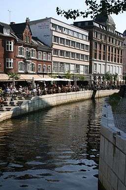
 The Aarhus flowing through the city centre of Aarhus. Here at Immervad close to its mouth on Aarhus Harbour. | |
| Country | Denmark |
|---|---|
| Region | Jutland |
| District | Central Denmark Region |
| Municipality | Skanderborg Municipality, Aarhus Municipality |
| Landmark | Stilling-Solbjerg Lake, Jeksendalen, Brabrand Lake, Aarhus |
| Source | Astrup Mose |
| - location | Skanderborg Municipality |
| - elevation | 54 m (177 ft) |
| Mouth | Aarhus Harbour |
| - location | Aarhus Bay |
| - elevation | 0 m (0 ft) |
| Length | 40 km (25 mi) |
| Basin | 324 km2 (125 sq mi) |
| Wikimedia Commons: Aarhus Å | |
The Aarhus (Danish: Aarhus Å) is a 40-kilometre (25 mi) long river or stream, in eastern Jutland, Denmark.
The Aarhus flows through the large river valley of the Aarhus Ådal. The valley itself stretches from Silkeborg to the coastal city of Aarhus, but the river runs only through the easternmost parts.[1] The river drains a basin of 324 square kilometres (125 sq mi) in the eastern part of Søhøjlandet and discharges into the Bay of Aarhus which is an embayment of the Kattegat. It originates 54 metres (177 ft) above sea level in the swampy bogland of Astrup Mose close to Stilling-Solbjerg Lake, southwest of the city of Aarhus (56°6' northern latitude, 10°9' eastern longitude) and exits into Aarhus Harbour at 56°9' northern latitude, 10°13' eastern longitude. The river defines the border between Skanderborg and Aarhus Municipality during its first few kilometres.
History
The Aarhus river has been important for the development of the city of Aarhus since its foundation in the early Viking Age and archaeological and historical research suggests that it played a crucial role in the origins of the city.[2]
References
- ↑ Marianne Krog Skajem. "Undervisningsforløb om Aarhus Ådal med særligt fokus på Brabrand Sø og Årslev Engsø" (PDF) (in Danish). NTS Centeret. Retrieved 25 November 2014. Educational material about Aarhus Ådal.
- ↑ "Facts about Aarhus River". Urban Media Space. Retrieved 25 November 2014.
Sources
- Søren Olsen: Danmarks Søer og Åer ISBN 87-567-6364-6 (Danish)
- Fode, Henrik et.al (2009): Århus Å. Natur og mennesker (Danish)
- Barbara Højlund & Frederik Schildt Nabe-Nielsen (2011): Aarhus Viking Ship Museum
- Christina Jessen (2011): Aarhus Danmarkshistorien.dk, Aarhus University.
External links
- Aarhus Å Den Gamle By. Paintings of the Aarhus through the ages.
- Aarhus danmarkshistorien.dk, Aarhus University (Danish)
Coordinates: 56°09′16″N 10°12′40″E / 56.15444°N 10.21111°E