Absaroka-Beartooth Wilderness
| Absaroka-Beartooth Wilderness | |
|---|---|
|
IUCN category Ib (wilderness area) | |
 | |
 | |
| Location | Montana / Wyoming, USA |
| Nearest city | Red Lodge, MT |
| Coordinates | 45°6′0″N 109°56′0″W / 45.10000°N 109.93333°WCoordinates: 45°6′0″N 109°56′0″W / 45.10000°N 109.93333°W |
| Area | 944,000 acres (3,820 km2) |
| Established | 1978 |
| Governing body | U.S. Forest Service |
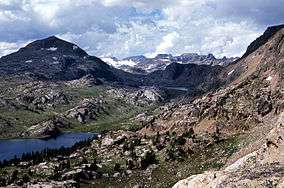
Absaroka-Beartooth Wilderness was created from existing National Forest lands in 1978 [1][2] and is located in Montana and Wyoming, United States. The wilderness is partly in Gallatin, Custer and Shoshone National Forests and is composed of 944,000 acres (3,820 km2). The wilderness encompasses two distinct mountain ranges, namely the Beartooth and Absaroka ranges. These ranges are completely distinct geologically speaking with the Absarokas composed primarily of volcanic (or extrusive) and metamorphic rock, while the Beartooths are made up almost entirely of granitic rocks. The Absarokas are noted for their dark and craggy appearance, lush and heavily forested valleys and abundant wildlife. The highest peak in the range, located in Wyoming, is Francs Peak at 13,153 feet (4,009 m). The Beartooths are more alpine with huge treeless plateaus and the highest peak in the state of Montana (Granite Peak 12,799 feet (3,901 m)). The wilderness contains 30 peaks over 12,000 feet (3,700 m).[3] The wilderness is an integral part of the 20-million-acre (81,000 km2) Greater Yellowstone Ecosystem and borders Yellowstone National Park.
Wilderness areas do not allow motorized or mechanical equipment including bicycles. Although camping and fishing are allowed with proper permit, no roads or buildings are constructed and there is also no logging or mining, in compliance with the 1964 Wilderness Act. Wilderness areas within National Forests and Bureau of Land Management areas also allow hunting in season.
There are 700 miles (1,100 km) of trails in the wilderness, hundreds of lakes, a few dozen streams and a similar number of small glaciers can be found in the wilderness. The forests are dominated by various species of spruce, fir and pine while in the Beartooth Mountains, due to the altitude, tundra conditions often prevail. The Beartooths have the largest unbroken area of land in excess of 10,000 feet (3,000 m) in altitude in the U.S. outside of Alaska. Animals found in the wilderness include bald eagles and yellowstone cutthroat trout and the threatened grizzly bear and lynx as well as the gray wolf.
Access to the wilderness is difficult but can be achieved via the Beartooth Highway US 212 from Red Lodge, Montana. There are also some forest access roads from the west off of US 89 south from Livingston, Montana.
Highlights
The Absaroka-Beartooth Wilderness is full of beautiful landscapes. Below are some of the highlights:
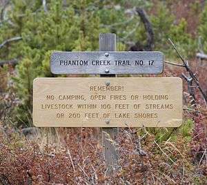
- East Rosebud- Many avid hikers say that "East Rosebud is the most scenic valley of all." It is filled with lakes and waterfalls that would be major tourism draws anywhere else. In fact, there are so many different waterfalls and lakes within this valley that many of them haven't been named.[4] Slough Lake is found within the East Rosebud valley and is not only beautiful, but great for fishing as it fills from Slough Creek which connects all the way to Yellowstone National Park. Slough Creek is known to connect to other lakes within the area that have large and stable populations of cutthroat trout, cutbow trout and the well-known rainbow trout.[5] Slough Lake is accessed by following the Phantom Creek Trail, which can also be used to access Granite Peak, which has an elevation of 12,799 feet (3,901 m) above sea level, and is the highest peak in Montana.[6]

- Mystic Lake-the deepest lake in the Beartooth Mountains. It has the largest sandy beach in the Beartooths and is a wonderful destination for a day hike. The Montana Power Company does utilize the power of this large lake, and they do have a dam present, but they do as much as possible to maintain the wilderness.[7] Mystic Lake supports a rainbow trout fishery, and the fishing is usually great when the fish are feeding. Hiking the trail up 3 miles (4.8 km) to Mystic Lake provides great views of West Rosebud Valley and a few other lakes.
See also
References
- ↑ Aarstad, Rich, et al. "Montana Place Names from Alzada to Zortman: A Montana Historical Society Guide". Montana Historical Society Press. Helena, Montana, 2009, p. 2
- ↑ "Absaroka-Beartooth Wilderness". Wilderness.net. Retrieved 2012-02-19.
- ↑ Aarstad, Rich, Ellie Arguimbau, Ellen Baumler, Charlene Porsild, and Brian Shovers. Montana Place Names from Alzada to Zortman. Montana Historical Society Press.
- ↑ Schneider, Bill. Best Easy Day Hikes: Absaroka-Beartooth Wilderness. 2nd ed. Guilford: Falcon Publishing, 2003. 21-23
- ↑ Marcuson, Pat. Fishing the Beartooths: An Angler's Guide to More Than 400 Prime Fishing Spots. 2nd ed. Guilford: Morris Book Publishing, LLC, 2008. 143-150
- ↑ "Phantom Creek Trail to Slough Lake." REI, 2008. Web. 12 Nov. 2012. <http://www.rei.com/guidepost/detail/montana/hiking/phantom-creek-trail-to-slough-lake/40628>.
- ↑ Schneider, Bill. Best Easy Day Hikes: Absaroka-Beartooth Wilderness. 2nd ed. Guilford: Falcon Publishing, 2003. 21-23
Further reading
- Silkwood, J.T. and G.N. Green. (2000). Generalized geologic map of the Absaroka-Beartooth study area, south-central Montana [U.S. Geological Survey Miscellaneous Field Studies; Map MF-2338]. Reston, VA: U.S. Department of the Interior, U.S. Geological Survey.
External links
- "Absaroka-Beartooth Wilderness". The National Wilderness Preservation System. Wilderness.net. Archived from the original on 11 October 2007. Retrieved 2007-09-16.
- "USGS Cooke City (MT,WY) Topo Map Quad". TopoQuest. Retrieved 2008-06-29.
- "Wilderness Legislation: The Wilderness Act of 1964". The National Wilderness Preservation System. Wilderness.net. Archived from the original on 11 September 2006. Retrieved 2006-08-16.