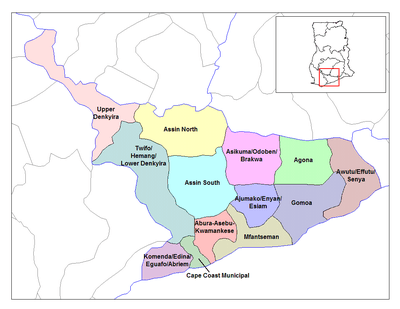
Abura-Dunkwa
| Abura-Dunkwa | |
|---|---|
| Town | |
 Abura-Dunkwa Location of Dunkwa-On-Offin in Central Region, South Ghana | |
| Coordinates: 5°58′0″N 1°47′0″W / 5.96667°N 1.78333°W | |
| Region | Central Region |
| District | Abura-Asebu-Kwamankese District |
| Elevation | 80 m (260 ft) |
| Time zone | GMT |
| • Summer (DST) | GMT (UTC) |
Abura-Dunkwa is a small town and the capital of Abura-Asebu-Kwamankese District, a district in the Central Region of south Ghana.[1][2]
Geography
Topography
Abura-Dunkwa is low-lying with loose quaternary sands and it rises up to 80 metres above sea level.[3] The town is drained by a number of rivers and streams, including the Offin River, Birim River and small streams.[3]
Education
Abura-Dunkwa is known for the Dunkwa secondary technical school, Boa Amponsem, Oxford, and St Andrews secondary schools.[4] The school is a second cycle institution.[5]
Transport
Abura-Dunkwa is a junction station on the narrow gauge Ghana Railway system.
References
- ↑ Abura-Asebu-Kwamankese district
- ↑ There are several places in South Ghana with the same name of Dunkwa.
- 1 2 Abura-Asebu-Kwamankese district: Topography
- ↑ "References » Schools/Colleges". Retrieved 12 August 2011.
- ↑ "List of Secondary Schools in Ghana". Retrieved 12 August 2011.
This article is issued from Wikipedia - version of the 10/3/2016. The text is available under the Creative Commons Attribution/Share Alike but additional terms may apply for the media files.
