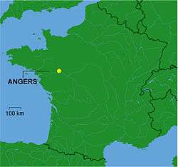
Agglomeration community of the Angers Loire Métropole
| Communauté d'agglomération d'Angers Loire Métropole | |
|---|---|
 | |
| Country | France |
| Region | Pays de la Loire |
| Department | Maine-et-Loire |
| No. of communes | 31 |
| Established | 2001 |
| Seat | Angers |
| Government | |
| • President | Jean-Claude Antonini |
| Area | |
| • Total | 510 km2 (200 sq mi) |
| Population (1999) | |
| • Total | 261,146 |
| • Density | 512/km2 (1,330/sq mi) |
| Budget | 295 millions € (2005) |
| Website |
Angers Loire Métropole Angers Developpement |
The Communauté d'agglomération d'Angers Loire Métropole is the intercommunal structure gathering the city of Angers and some of its suburbs.
It's located in the Maine-et-Loire département, in the Pays de la Loire région (France).
Composition
The Communauté d'agglomération d'Angers Loire Métropole gathers 31 communes :
- Angers
- Avrillé
- Beaucouzé
- Béhuard
- Bouchemaine
- Briollay
- Cantenay-Épinard
- Écouflant
- Feneu
- La Meignanne
- La Membrolle-sur-Longuenée
- Montreuil-Juigné
- Mûrs-Erigné
- Pellouailles-les-Vignes
- Le Plessis-Grammoire
- Le Plessis-Macé
- Les Ponts-de-Cé
- Saint-Barthélemy-d'Anjou
- Saint-Clément-de-la-Place
- Sainte-Gemmes-sur-Loire
- Saint-Jean-de-Linières
- Saint-Lambert-la-Potherie
- Saint-Léger-des-Bois
- Saint-Martin-du-Fouilloux
- Saint-Sylvain-d'Anjou
- Sarrigné
- Savennières
- Soucelles
- Soulaines-sur-Aubance
- Trélazé
- Villevêque
Coordinates: 47°30′N 0°33′W / 47.500°N 0.550°W
This article is issued from Wikipedia - version of the 6/21/2013. The text is available under the Creative Commons Attribution/Share Alike but additional terms may apply for the media files.