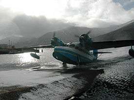
Akutan Seaplane Base
| Akutan Seaplane Base | |||||||||||
|---|---|---|---|---|---|---|---|---|---|---|---|
 | |||||||||||
| IATA: was KQA – ICAO: none – FAA LID: KQA | |||||||||||
| Summary | |||||||||||
| Airport type | Public | ||||||||||
| Owner | City of Akutan | ||||||||||
| Serves | Akutan, Alaska | ||||||||||
| Location | Akutan Island | ||||||||||
| Elevation AMSL | 0 ft / 0 m | ||||||||||
| Coordinates | 54°08′02″N 165°46′42″W / 54.13389°N 165.77833°WCoordinates: 54°08′02″N 165°46′42″W / 54.13389°N 165.77833°W | ||||||||||
| Map | |||||||||||
 KQA Location of airport in Alaska | |||||||||||
| Runways | |||||||||||
| |||||||||||
| Statistics (2010) | |||||||||||
| |||||||||||

Akutan Seaplane Base (IATA: was KQA[2], FAA LID: KQA) is a public use seaplane base located in Akutan,[1] a city on Akutan Island in the Aleutians East Borough of the U.S. state of Alaska. Scheduled seaplane service was subsidized by the Essential Air Service program until late 2012 when PenAir retired their Grumman Goose amphibious aircraft and a new land-based airport on neighboring Akun Island was built. The new airport is known as Akutan Airport.
As per Federal Aviation Administration records, the airport had 1,346 passenger boardings (enplanements) in calendar year 2008,[3] 1,200 enplanements in 2009, and 1,246 in 2010.[4] It is included in the National Plan of Integrated Airport Systems for 2011–2015, which categorized it as a general aviation airport (the commercial service category requires at least 2,500 enplanements per year).[5]
Statistics
| Carrier | Passengers (arriving and departing) |
|---|---|
| Peninsula | 1,610(100%) |
| Rank | Destination | Airport | Passengers | |
|---|---|---|---|---|
| 2012 | 2011 | |||
| 1 | Unalaska, AK | Unalaska Airport (DUT) | 710 | 1,000 |
See also
- Akutan Airport (FAA: 7AK) located at 54°08′41″N 165°36′15″W / 54.14472°N 165.60417°W
References
- 1 2 FAA Airport Master Record for KQA (Form 5010 PDF). Federal Aviation Administration. Effective April 5, 2012.
- ↑ "IATA Airport Code Search (KQA: Akutan)". International Air Transport Association. Retrieved June 11, 2014.
- ↑ "Enplanements for CY 2008" (PDF, 1.0 MB). CY 2008 Passenger Boarding and All-Cargo Data. Federal Aviation Administration. December 18, 2009.
- ↑ "Enplanements for CY 2010" (PDF, 189 KB). CY 2010 Passenger Boarding and All-Cargo Data. Federal Aviation Administration. October 4, 2011.
- ↑ "2011–2015 NPIAS Report, Appendix A" (PDF). National Plan of Integrated Airport Systems. Federal Aviation Administration. October 4, 2010. Archived from the original (PDF, 2.03 MB) on 2012-09-27.
- 1 2 "Akutan, AK: Akutan Airport (KQA)". Bureau of Transportation Statistics (BTS), Research and Innovative Technology Administration (RITA), U.S. Department of Transportation. December 2013. Retrieved June 11, 2014.
Other sources
- Essential Air Service documents (Docket DOT-OST-2000-7068) from the U.S. Department of Transportation:
- Order 2005-5-12 (May 19, 2005): re-selecting Peninsula Airways (PenAir) to provide essential air service at Akutan, Alaska, at an annual subsidy rate of $350,381, for the two-year period May 1, 2005, through April 30, 2007.
- Order 2007-3-3 (March 9, 2007): re-selecting Peninsula Airways (PenAir) to provide subsidized essential air service at Akutan, Alaska, for the period from May 1, 2007, through April 30, 2009, at an annual subsidy rate of $556,155.
- Order 2009-5-4 (May 5, 2009): selecting Peninsula Airways (PenAir) to provide essential air service at Akutan for an annual subsidy rate of $654,964, through April 30, 2011.
- Order 2011-3-31 (March 25, 2011): re-selecting Peninsula Airways, Inc., (PenAir) to provide essential air service (EAS) at Akutan, Alaska, at annual subsidy rate of $710,157, from May 1, 2011, through April 30, 2013.
- Notice of Termination of Service (August 6, 2012): Peninsula Airways, Inc. (“PenAir”) hereby gives notice of its intent to discontinue all of its service to Akutan, Alaska, as soon as replacement service begins. PenAir respectfully requests that the Department promptly issue a request for proposals to enable PenAir to terminate service on September 1, 2012, or as soon thereafter as possible.
External links
- Topographic map from USGS The National Map
- Resources for this airport:
- FAA airport information for KQA
- AirNav airport information for KQA
- ASN accident history for KQA
- FlightAware airport information and live flight tracker
- SkyVector aeronautical chart for KQA