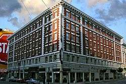
Ambassador Hotel (San Francisco)


The Ambassador Hotel is a six-story, 134 room single room occupancy hotel at 55 Mason Street in the Tenderloin district of San Francisco, California.[1] The hotel was designed by Earl B. Scott & K. McDonald as the Ferris Harriman Hotel and Theater, and completed in 1911. An addition was completed in 1922, and in 1923 the hotel was renamed Hotel Ambassador. In 1929 the theater was converted to a garage.[2]
True crime author Miriam Allen deFord was a noted resident from 1936 until her death in 1975. From 1978 to 1996, the hotel was managed by Hank Wilson, a San Francisco LGBT activist,[3] who made the hotel a model for harm reduction housing.
In 1993, photographer Paul Fusco published a series of photographs of some of the residents living with AIDS.[4]
Over many years, the hotel deteriorated. In 1994, KRON, San Francisco's channel 4, aired a documentary about the hotel and its residents[3] called Life and Death at the Ambassador Hotel which documented the hotel's use as harm reduction housing.
During the late 1990s, a collection of activist and labor organizations worked with residents to organize to improve the buildings. The now defunct Eviction Defense Network collaborated with ACT-UP SF to outreach to tenants, resulting in a successful Rent Board decision to lower most of the resident's rents due to dilapidated conditions. The Housing Rights Committee helped connect residents to an attorney who filed a successful class action lawsuit against the landlord. Tenderloin Housing Clinic pursued a strategy of filing complaints through the Department of Building Inspection. These tactics influenced the landlord's decision to sell the property.
In 2000, the property was acquired by Tenderloin Neighborhood Development Corporation (TNDC), a non profit corporation that buys and repairs properties mostly in the San Francisco Tenderloin. Repairs were completed in November 2003, and it now serves as low income housing.[1]
See also
References
Coordinates: 37°47′03″N 122°24′34″W / 37.784108°N 122.409359°W
External links
- Life and Death at the Ambassador Hotel, part 1 of four
- Article about Hank Wilson and his role at the Ambassador, by the San Francisco Study Center