Arkansas Highway 14
| ||||
|---|---|---|---|---|
 | ||||
| Route information | ||||
| Maintained by AHTD | ||||
| Length: | 227.35 mi[1] (365.88 km) | |||
| Existed: | April 1, 1926[2] – present | |||
| Major junctions | ||||
| West end: | Boat Dock Road, Table Rock Lake | |||
|
| ||||
| East end: |
| |||
| Location | ||||
| Counties: | Boone, Marion, Searcy, Baxter, Stone, Independence, Jackson, Poinsett, Mississippi | |||
| Highway system | ||||
| ||||

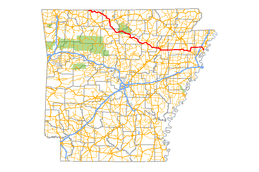
Highway 14 (AR 14, Ark. 14, and Hwy. 14) is an east–west state highway in north Arkansas. The route of 227.35 miles (365.88 km) begins at Boat Dock Road near Table Rock Lake and runs east to Mississippi County Route W1020 (CR W1020) at Golden Lake.[3] The highway's general alignment between the western terminus and Marked Tree closely follows the original routing as established in the initial 1926 Arkansas state highway numbering plan. The route from Highway 140 in Lepanto east across Interstate 55 to Golden Lake is a later extension.
Route description
After Marked Tree, AR 14 meets with US 63 for a stretch, before heading to Harrisburg, where it crosses AR 1. Highway 14 then goes on to Waldenburg, where it meets US 49 and AR 214, Newport (crossing US 67) and Batesville (AR 25). The route then passes through Buffalo River State Park on its way to meeting US 412 in Yellville. Arkansas Highway 14 continues to AR 7 and Lead Hill before merging onto old US 65 (now AR 365[4]) at Omaha. This leads to the end of the route, when AR 14 becomes Boat Dock Road and ends in a cul-de-sac at Table Rock Lake.
Arkansas Highway 14 travels north to Marie where it adjuncts AR 181. Interstate 55 meets AR 14 outside of Marie as Exit 41. The road continues to Lepanto, where it meets AR 135 and becomes concurrent with AR 140 until Marked Tree.
History

The route was first designated in 1926 in the original state highway numbering. State Road 14 ran from Omaha east to Marked Tree in Poinsett County.[2]
In 1978, Highway 14 was rerouted south of Batesville. The mainline Highway 14 was rerouted over existing Highway 25 and supplanted Highway 14A. The former Highway 14 mainline route was redesignated as Highway 230 between Locust Grove and Southside. A short original section of Highway 14 between Southside and Salado, discontinuous after the rerouting, was redesignated Highway 14 Spur.[5]
Major intersections
Mile markers reset at some concurrencies.
| County | Location | mi[1] | km | Destinations | Notes |
|---|---|---|---|---|---|
| Boone | | 0.00 | 0.00 | Table Rock Lake, Cricket Recreation Area | state maintenance ends about 1⁄2 mile (0.80 km) east of the entrance |
| | 4.34 | 6.98 | west end of US 65 overlap | ||
| | 0.00 | 0.00 | east end of US 65 overlap | ||
| Omaha | Main Street - Harrison | former US 65 south | |||
| | 15.04 | 24.20 | west end of AR 281 overlap | ||
| | 15.99– 16.27 | 25.73– 26.18 | east end of AR 281 overlap | ||
| Lead Hill | 23.33 | 37.55 | west end of AR 7 overlap | ||
| | 24.55 | 39.51 | east end of AR 7 overlap | ||
| Marion | | 25.70 | 41.36 | ||
| | 32.81 | 52.80 | |||
| | 36.07 | 58.05 | |||
| Summit | 46.97 | 75.59 | |||
| Yellville | 48.45 | 77.97 | west end of US 62 / US 412 overlap | ||
| 0.00 | 0.00 | east end of US 62 / US 412 overlap | |||
| 0.54 | 0.87 | ||||
| Ralph | 4.27 | 6.87 | |||
| Mull | 14.15 | 22.77 | |||
| Searcy | Harriet | 23.55 | 37.90 | ||
| Baxter | Big Flat | 31.59 | 50.84 | ||
| | 36.49 | 58.72 | |||
| Stone | | 46.95 | 75.56 | ||
| Allison | 53.21 | 85.63 | west end of AR 5 / AR 9 overlap | ||
| Mountain View | |||||
| 0.00 | 0.00 | east end of AR 9 overlap | |||
| 1.68 | 2.70 | east end of AR 5 overlap | |||
| | 7.47 | 12.02 | |||
| Independence | Locust Grove | 28.47 | 45.82 | west end of AR 25 overlap | |
| Dennison Heights | 0.00 | 0.00 | east end of AR 25 overlap | ||
| Salado | 3.68 | 5.92 | |||
| | 12.67 | 20.39 | |||
| Oil Trough | 14.01 | 22.55 | Ferry Road | former AR 932-1 | |
| | 15.43 | 24.83 | |||
| Jackson | | 23.76 | 38.24 | west end of AR 367 overlap | |
| Newport | Newport Bridge over White River | ||||
| 0.00 | 0.00 | Remmel Avenue | former AR 224 east | ||
| 0.69 | 1.11 | ||||
| Pecan Street | former AR 17 north | ||||
| 1.70 | 2.74 | east end of AR 367 overlap | |||
| 2.35 | 3.78 | former AR 224 west | |||
| | 4.80 | 7.72 | US 67 exit 80 | ||
| | 5.00 | 8.05 | |||
| Erwin | 6.57 | 10.57 | |||
| 6.81 | 10.96 | ||||
| | 9.63 | 15.50 | |||
| Amagon | 13.32 | 21.44 | |||
| | 15.90 | 25.59 | |||
| Poinsett | Waldenburg | 23.54 | 37.88 | ||
| Harrisburg | 35.15 | 56.57 | |||
| | 36.03 | 57.98 | west end of AR 163 / CRP overlap | ||
| | 36.49 | 58.72 | east end of AR 163 / CRP overlap | ||
| Landers | 42.14 | 67.82 | |||
| Weona | 43.92 | 70.68 | |||
| Payneway | 49.48 | 79.63 | |||
| | 49.88 | 80.27 | west end of US 63 overlap; AR 14 west follows exit 18 | ||
| Marked Tree | east end of US 63 overlap; west end of US 63B overlap; AR 14 east follows exit 14 | ||||
| east end of US 63B overlap; west end of AR 140 overlap | |||||
| Lepanto | |||||
| 0.00 | 0.00 | east end of AR 140 overlap | |||
| Mississippi | | 4.44 | 7.15 | ||
| | 6.34 | 10.20 | |||
| | 12.00 | 19.31 | I-55 exit 41 | ||
| Marie | 13.38 | 21.53 | |||
| 13.76 | 22.14 | ||||
| Wilson | 17.70 | 28.49 | |||
| Golden Lake | 19.24 | 30.96 | |||
1.000 mi = 1.609 km; 1.000 km = 0.621 mi
| |||||
Auxiliary routes of Highway 14
Spur route
| |
|---|---|
| Location: | Independence County |
| Length: | 1.34 mi[1] (2.16 km) |
| Existed: | May 26, 1978[5]–present |
Highway 14 Spur (AR 14S, Ark. 14S, and Hwy. 14S) is a spur route of 1.34 miles (2.16 km) in Independence County.
- Route description
The route begins at Highway 14 at Salado and runs west to US 67 and Highway 230 at Southside.
- History
Highway 14S was created on May 26, 1978 during a rerouting of Highway 14 in the vicinity. Mainline Highway 14 ran along present-day Highway 230 and Highway 14S. The main route was shifted to a concurrency with Highway 25, with a redesignation of the former alignment as Highway 230 to the west of US 167 and Highway 14S to the east.[5]
- Major intersections
The entire route is in Independence County.
| Location | mi[1] | km | Destinations | Notes | |
|---|---|---|---|---|---|
| Salado | 0.00 | 0.00 | Eastern terminus | ||
| Southside | 1.34 | 2.16 | Western terminus, eastern terminus of AR 230 | ||
| 1.000 mi = 1.609 km; 1.000 km = 0.621 mi | |||||
Alternate route
| |
|---|---|
| Location: | Independence County |
| Length: | 3.68 mi[5] (5.92 km) |
| Existed: | June 23, 1965[6]–May 26, 1978[5] |
Highway 14 Alternate (AR 14A, Ark. 14A, and Hwy. 14A) is a former alternate route of 1.34 miles (2.16 km) in Independence County.[5]
- Route description
Highway 14A began at Highway 14 at Salado and ran northeast to Ramsey Hill, terminating at US 167 and Highway 25.
- History
The route was added to the state highway system on June 23, 1965.[6] Highway 14A was supplanted by mainline Highway 14 during a rerouting in 1978.[5]
- Major intersections
The entire route is in Independence County.
| Location | mi[1] | km | Destinations | Notes | |
|---|---|---|---|---|---|
| Salado | 0.00 | 0.00 | Southern terminus | ||
| Ramsey Hill | 3.68 | 5.92 | Western terminus, eastern terminus of AR 25 | ||
| 1.000 mi = 1.609 km; 1.000 km = 0.621 mi | |||||
References
- 1 2 3 4 5 Planning and Research Division (2010). "Arkansas Road Log Database". Arkansas State Highway and Transportation Department. Archived from the original (Database) on 23 June 2011. Retrieved June 9, 2011.
- 1 2 Arkansas State Highway Commission (April 1, 1926). Map of the State of Arkansas Showing System of State Highways (TIF) (Map). Arkansas State Highway Commission. Retrieved November 19, 2016.
- ↑ General Highway Map, Mississippi County, Arkansas (PDF) (Map). 1:62500. Cartography by Planning and Research Division. Arkansas State Highway and Transportation Department. January 11, 2010. Retrieved January 13, 2012.
- ↑ 1936 Pulaski County Map
- 1 2 3 4 5 6 7 "Minutes" (1970–79), p. 269.
- 1 2 "Minutes" (1953–69), p. 669.
- "Minutes of the Meeting" (PDF). Arkansas State Highway Commission. 1953–69. Retrieved November 19, 2016.
- "Minutes of the Meeting" (PDF). Arkansas State Highway Commission. 1970–79. Retrieved November 19, 2016.