Arkansas Highway 51
| ||||
|---|---|---|---|---|
 | ||||
| Route information | ||||
| Maintained by AHTD | ||||
| Existed: | April 1, 1926[1] – present | |||
| Section 1 | ||||
| Length: | 57.37 mi[2] (92.33 km) | |||
| South end: |
| |||
| North end: |
| |||
| Section 2 | ||||
| Length: | 7.92 mi[2] (12.75 km) | |||
| South end: |
| |||
| North end: |
| |||
| Location | ||||
| Counties: | Clark, Hot Spring | |||
| Highway system | ||||
| ||||

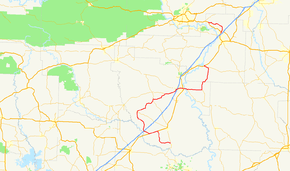
Highway 51 (AR 51, Ark. 51, and Hwy. 51) is a designation for two north–south state highways in Southwest Arkansas. One route of 53.37 miles (85.89 km) begins Highway 53 near Whelen Springs and runs north to US Highway 67 (US 67) in Donaldson. A second route of 7.92 miles (12.75 km) runs parallel to US 270 northwest of Malvern. Both routes are maintained by the Arkansas State Highway and Transportation Department (AHTD).
History
Highway 51 was created during the 1926 Arkansas state highway numbering as a route between US 67 and Arkadelphia in Clark County.[1]
Major intersections
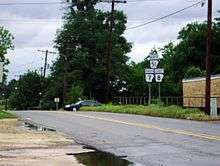
Highway 7, 8, and 51 reassurance markers in Arkadelphia
Mile markers reset at concurrencies.
| County | Location | mi[2] | km | Destinations | Notes | ||
|---|---|---|---|---|---|---|---|
| Clark | | 0.00 | 0.00 | Southern terminus | |||
| | 8.18– 0.00 | 13.16– 0.00 | |||||
| | 2.42 | 3.89 | |||||
| Okolona | 10.24 | 16.48 | Western terminus of AR 182 | ||||
| | 18.15– 18.99 | 29.21– 30.56 | Officially designated exception | ||||
| | 24.24 | 39.01 | Eastern terminus of AR 26 | ||||
| Arkadelphia | 28.91 | 46.53 | Begin AR 8 overlap | ||||
| 29.09 | 46.82 | ||||||
| 31.31 | 50.39 | Begin US 67/AR 7 overlap | |||||
| 0.00 | 0.00 | End US 67 overlap | |||||
| | 1.57 | 2.53 | End AR 7/AR 8 overlap | ||||
| Joan | 6.74 | 10.85 | Eastern terminus of AR 128 | ||||
| Hot Spring | | 15.83 | 25.48 | Western terminus of AR 222 | |||
| Donaldson | 17.35 | 27.92 | Eastern terminus of AR 51Y | ||||
| 17.88 | 28.78 | Northern terminus | |||||
| Gap in route | |||||||
| Rockport | 0.00 | 0.00 | Southern terminus | ||||
| | 7.92 | 12.75 | Northern terminus | ||||
1.000 mi = 1.609 km; 1.000 km = 0.621 mi
| |||||||
See also
-
 Arkansas portal
 -
 U.S. Roads portal
Notes
References
- 1 2 Arkansas State Highway Commission (April 1, 1926). Map of the State of Arkansas Showing System of State Highways (TIF) (Map). Arkansas State Highway Commission. Retrieved November 18, 2016.
- 1 2 3 System Information and Research Division (2014). "Arkansas Road Log Database" (MDB). Arkansas State Highway and Transportation Department. Retrieved March 27, 2016.
- "Minutes of the Meeting" (PDF). Arkansas State Highway Commission. 1953–69. Retrieved November 18, 2016.
External links
-
 Media related to Arkansas Highway 51 at Wikimedia Commons
This article is issued from Wikipedia - version of the 11/21/2016. The text is available under the Creative Commons Attribution/Share Alike but additional terms may apply for the media files.