Arthur, Ontario
| Arthur | |
|---|---|
| Unincorporated community | |
|
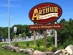
The Village of Arthur Sign at the Intersection of Hwy 6 and Wellington Road 109. | |
| Coordinates: 43°49′58″N 80°32′16″W / 43.83278°N 80.53778°WCoordinates: 43°49′58″N 80°32′16″W / 43.83278°N 80.53778°W | |
| Country | Canada |
| Province | Ontario |
| County | Wellington County |
| Township | Wellington North |
| Area | |
| • Total | 524.38 km2 (202.46 sq mi) |
| • Density | 21.3/km2 (55/sq mi) |
| Time zone | EST (UTC-5) |
| • Summer (DST) | EDT (UTC-4) |
| Forward sortation area | N0G 1A0 |
| Area code(s) | 519 and 226 |
| NTS Map | 040P15 |
| GNBC Code | FADVI |
Arthur (population 2,450) is a community located just north of Highway 6 and Wellington Road 109 in the township of Wellington North, Ontario, Canada. Formerly an independent village, Arthur was amalgamated into Wellington North on January 1, 1999.
History
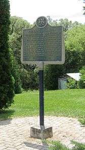
Arthur Village was named after Arthur Wellesley, 1st Duke of Wellington. Arthur Village was first surveyed in 1841 by John McDonald and then officially in 1846 by D.B. Papineau. During the first survey in 1841, the population of Arthur was 22 people. Over the next 15 years this number rose to 400 and by 1900 the population has risen to just over 1500. The establishment of saw and grist mills sparked growth in the community. In 1851, a post office was opened and the first church and school were organized. Development was further encouraged in 1872 when a station of the Toronto, Grey and Bruce Railway was opened.
The Arthur Enterprise News, established in 1863, was one of the few non-syndicated weekly newspapers in Canada.
In 1897, Arthur was one of the first villages in Ontario to be served by a power transmission line. There were no meters, but people were charged 10 cents for each lightbulb used. Power was available in the evenings and was cut off at midnight.
In 1906, Joe Sussman and his two brothers moved from Poland to the clothing district in Toronto. Joe moved to the Arthur area and would drive a horse-drawn carriage along the countryside, taking clothing to people who lived on farms, and also would help out on farms if help was needed. In 1914, Joe settled his store at a permanent location, and the store quickly became popular with people from Arthur and surrounding areas. Today, Sussman's of Arthur is one of the largest independently owned clothiers in Canada.
Canada's Most Patriotic Village
In November 1942, the Toronto Star ran a front page headline that read "Arthur Village Gives Sons and Money to Aid the War", and recognized Arthur as the Most Patriotic Village in Canada, as one out of every seven Arthur residents fought in the Second World War. At that time 126 residents had enlisted from the population of 890. It was the highest ratio in comparison to villages of comparable sizes in Canada. By the end of the war, 338 Arthur residents had enlisted, and 25 were killed in action.
During the first war bond campaign of World War II, the village of Arthur was the first community in Ontario to reach its quota within a few minutes. Arthur also led the communities in Wellington for every other war and victory bond campaign and surpassed all objectives that had been set. By the end of the fourth campaign, Arthur had raised a total of $250,000 which was an amount equal to 64% of the assessed value of the village's taxable property.
In 2002, David Tilson, MPP for Dufferin—Peel—Wellington—Grey stated in the Ontario legislature, that because of the village of Arthur’s extraordinary World War II record, the community was now being recognized as “Canada’s Most Patriotic Village”.
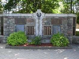
The sacrifice of these soldiers is honoured by the Cenotaph of Arthur, located in the heart of the village. The monument was unveiled on August 6, 1923 by Mrs. David Brocklebank, whose son was killed at the end of World War I, before the largest crowd ever assembled in Arthur village. After the unveiling the Toronto Star described the cenotaph as "a war memorial whose design and beauty cannot be equaled as yet in the Province." On the cenotaph are engraved the names of the 193 men who enlisted in World War I (including the 40 who were KIA), as well as the 363 men and women who enlisted in World War II, among whom 25 made the ultimate sacrifice. One unique feature of the cenotaph was that when it was being designed a decision was made to build the monument with stones gathered from local farms. It was later discovered that the memorial was the first fieldstone Cenotaph Memorial built in the province.
Murals of Arthur
The Arthur historical society is responsible for the murals which honour Arthur’s rich historical heritage and designation as Canada’s “Most Patriotic Village”. There are four sites in the village to visit. In order of commission by the Arthur Mural committee which is made up of four members of the Arthur Historical Society. Walking tours of the murals can be arranged through the Historical Society. Call John Walsh at 519-848-3015 for more information.
The Pioneer Mural
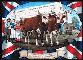
The Pioneer Mural in Arthur is painted on the South wall of the Hunter Tax Management Office at the southern entrance to the village. The location of this mural is symbolic as this office building is the former County Registry Office.
The mural itself depicts an early settler departing from the Registry Office with family and his yoke of oxen. The settler has in his hands his ‘location papers’ which entitles him to a free 50 acre plot of land in Arthur Township. To reach his property he would have travelled north on the Garafraxa Road, what is now highway 6.
This was the first of several murals commissioned by the Arthur Mural Committee and was designed and painted by artist Allen C.Hilgendorf in 2011.

The Veteran’s Mural
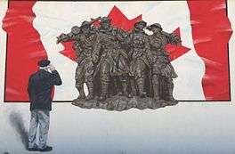
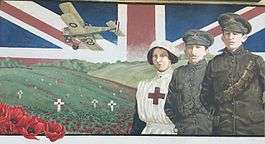
The Veteran’s Mural is a three paneled mural painted on the side wall of Sussman’s at the corner of Frederick St. and Smith St. Facing the United Church of Arthur. This mural is dedicated to the veterans of Arthur, male and female, who valiantly represented their village and country in the First and Second World Wars, and all conflicts since.
As mentioned previously Arthur is recognized by the Ontario Provincial Legislature as being the Most Patriotic Village in Canada. The panel furthest to the right represents the First World War and contains two soldiers, a nurse, a World War I-era military biplane, and a military cemetery with poppies growing all set against a Union Jack. The middle panel was designed to represent the Second World War and is the recreation of local veteran John Walsh saluting the National War Memorial in Ottawa set against a Canadian flag. The final panel on the left represents both World War II and all conflicts since 1945 in which Canadian soldiers have participated including Cyprus, the former Yugoslavia, Afghanistan, and Korea. This panel features a World War II-era mine sweeping ship, a tank, an anti-aircraft gun and a Spitfire war plane; along with former local military officer Moira McDougall who was a female military officer and Jim Dingman who was a UN peacekeeper, both whom lived in Arthur.
This was the second mural commissioned by the Arthur Mural Committee in 2012, and was the first painted by artist Cliff Smith. These eye-catching memorials were designed to remind residents and visitors alike that the past should not be forgotten; especially not the absolute sacrifice soldiers make for freedom.

Jones Baseline Mural
The Jones Baseline Mural is mounted on the side of the local business Re-Finish It, on the corner of George St. and Charles St. This mural was completed in the spring of 2013 as a partnership between the Arthur and Area Historical Society and the Native Community Council.
This mural outlines the importance of the survey in 1792 made by Augustus Jones and his team of thirteen men, seven of them being Native guides. This survey was commissioned by Governor Simcoe and took Jones and his survey team from Burlington Bay to the Conestoga River near present-day Arthur. The surveyors encountered many impediments to their progress ranging from geographic factors such dense bush, swamps, uneven terrain, to a variety of wildlife including black bears, rattlesnakes, and mosquitoes. Ultimately the explorers prevailed and the now the Baseline is used to form the boundary for many nearby townships, and also as the basis of the Six Nations land Grant.
This is the third mural commissioned by the Arthur Mural Committee, and was the second painted by artist Cliff Smith in 2013.
The Cenotaph Mural
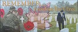
The Cenotaph mural is free standing at the cenotaph. The three men pictured have strong military families. Rick Dingman’s father was in the army in World War II and served in Italy and other family members served for many years. John Walsh’s grandfather (also John Walsh) served in the Canadian Navy in World War II and two great uncles served in the peacetime army. The soldier standing in the cemetery is Ken Waters who took part in the D-Day Invasion in World War II. He also comes from a family with strong military ties. This memorial was designed to remind residents and visitors alike that the past should not be forgotten: especially not the absolute sacrifice that our soldiers have made for freedom.
This is the fourth mural commissioned by the Arthur Mural Committee, and was the third painted by artist Cliff Smith in 2014.
Demographics
Populations for the Township of Wellington North (2011 Statistics Canada Census):
- Arthur: 2,427
- Mount Forest: 4,757
- Rural Wellington North: 4,299
- Total Population for the Township of Wellington North: 11,477
- Population Density: 21.8 persons/km2
Education
Arthur High School
Built in 1890 and located on Smith Street, the first Arthur High School was constructed by D.M. McPherson. At the time it opened there were 53 students and 2 teachers but after an addition was built in 1906 it had doubled in size. Joining the teaching staff in 1927 and becoming principal three years later, P.E. Brown stayed on as principal until his retirement in 1967. In 1953, a larger high school was built along Conestoga Street which was able to hold many more students until it closed in 2004. The building has now been converted into the new home for Arthur Public School. Students from the Arthur community now attend high school at the Wellington Heights Secondary School in the neighboring town of Mount Forest.
Arthur Public School
Constructed in 1945 on the same grounds as the previous public school, the building on Eliza Street stayed open until 2005 when the school was then relocated to the old high school building on Conestoga Street.
St. John’s Catholic School
Originally built in 1884; St. John’s School was located on Georgina Street beside the St. John’s Church. This school was demolished and replaced with a one storey school in 1963. A new school was built on the east end of Tucker Street in 1995 where Catholic students from the Arthur area still attend. The former school on Georgina Street is now being used as a Parish Centre for St. John’s Church.
Famous Connections
- Chad Culp - lacrosse player from Arthur
- James J. Morrison – born in Arthur and became a political activist for Ontario farmers’ rights
- Olive Palmer – Arthur District High School teacher from 1938-1939 later married Prime Minister John Diefenbaker
- William Lyon Mackenzie – leader of the Upper Canada rebellion once owned a 100-acre farm on the outskirts of Arthur
- Rixon Rafter – born in Arthur and became the first blind newspaper editor in Canada in 1908
- Jamie Rooney (lacrosse) - lacrosse player from Arthur
External links
| Wikimedia Commons has media related to Arthur, Ontario. |
- Arthur at Geographical Names of Canada
- Ontario Plaques - Founding of Arthur
- Ontario Plaques - James Morrison 1861-1936
- - Township of Wellington North Website
 |
Mount Forest Kenilworth |
Conn |  | |
| Palmerston | |
Grand Valley, Orangeville | ||
| ||||
| | ||||
| Drayton Moorefield |
Alma Elora |
Fergus Guelph |
