Aston-sub-Edge
| Aston-sub-Edge | |
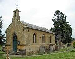
 St Andrew's church |
|
 Aston-sub-Edge |
|
| Population | 107 (2011)[1] |
|---|---|
| OS grid reference | SP142411 |
| Civil parish | Weston Sub Edge Parish |
| District | Cotswold |
| Shire county | Gloucestershire |
| Region | South West |
| Country | England |
| Sovereign state | United Kingdom |
| Post town | CHIPPING CAMPDEN |
| Postcode district | GL55 6 |
| Dialling code | 01386 |
| Police | Gloucestershire |
| Fire | Gloucestershire |
| Ambulance | South Western |
| EU Parliament | South West England |
| UK Parliament | The Cotswolds (UK Parliament constituency) |
|
|
Coordinates: 52°04′23″N 1°48′04″W / 52.073°N 1.801°W
Aston Subedge (also written Aston-sub-Edge) is a village and civil parish in the Cotswold district of Gloucestershire, England, close by the border with Worcestershire (to the west). According to the 2001 census the population was 55, increasing to 107 at the 2011 census.[2] The village is about 8 miles east of Evesham, and near the village of Weston Sub Edge.
The church of St Andrew was built in 1797 by Thomas Johnson of Warwick.
Dover's Hill lies about 1 mile (2 km) to the south of Aston Subedge.
References
- ↑ "Parish population 2011.Retrieved 12 September 2015".
- ↑ "Parish population 2011.Retrieved 22 March 2015". Archived from the original on 4 March 2016.
- David Verey, Gloucestershire: the Cotswolds, The Buildings of England edited by Nikolaus Pevsner, 2nd ed. (1979) ISBN 0-14-071040-X, p. 92
External links
| Wikimedia Commons has media related to Aston-sub-edge. |
This article is issued from Wikipedia - version of the 10/20/2016. The text is available under the Creative Commons Attribution/Share Alike but additional terms may apply for the media files.