Auchencairn
| Auchencairn | |
| Scottish Gaelic: Achadh an Cairn | |
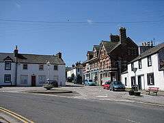
 The village of Auchencairn |
|
 Auchencairn |
|
| Population | 200 (approx) |
|---|---|
| OS grid reference | NX798513 |
| Civil parish | Rerrick |
| Council area | Dumfries and Galloway |
| Lieutenancy area | Dumfries |
| Country | Scotland |
| Sovereign state | United Kingdom |
| Post town | DUMFRIES |
| Postcode district | DG7 |
| Police | Scottish |
| Fire | Scottish |
| Ambulance | Scottish |
| EU Parliament | Scotland |
| UK Parliament | Dumfries and Galloway |
| Scottish Parliament | Dumfries |
| Website | Auchencairn.org.uk |
Coordinates: 54°50′31″N 3°52′19″W / 54.841971°N 3.871822°W
Auchencairn is a village in Dumfries and Galloway, Scotland. It is located on the coast of the Solway Firth at the head of Auchencairn Bay and lies on the A711 road between the town of Dalbeattie to the east and Kirkcudbright to the west.
Etymology
The name Auchencairn comes from the Scottish Gaelic 'Achadh an càirn' or 'Achadh nan carn' which translates as 'the field of the cairn'.[1][2]
Services
Facilities available in Auchencairn include:[3]
- the Smugglers Inn, a public house dating from the 18th century
- a village store and post office, which was opened by the Princess Royal in March, 2008
- Auchencairn Garage, provides auto-repairs, servicing and fuel
- Auchencairn Primary School, which has around 45 pupils
- A mobile library
- St. Oswald's Church, belonging to the Church of Scotland it was opened in 1855[4]
- A bus service connects the village to Dalbeattie, Kirkcudbright and Castle Douglas
- A hotel and a number of bed and breakfasts and holiday cottages can be found in the local area
History

There is evidence of human habitation of the area since the Mesolithic period, but the first written record of Auchencairn occurs from 1305 in a charter of Edward I in which 'Aghencarne' is listed among lands belonging to Dundrennan Abbey. In the early 17th century the village grew around the corn mill, and many of the older stone buildings in the village date from this time.[5]
From 1750 onwards, Auchencairn Bay became the centre of extensive smuggling activity in the area, with many of the local inhabitants being involved. This history is reflected in the name of the village pub, the Smugglers Inn.
Poltergeist incident
At the top end of the village stands a dead tree; it is all that remains of a farm called the Ringcroft of Stocking, the site of the 'Mackie Poltergeist' incident in 1695.[5][6] Over a period of several months, the inhabitants, a farmer Andrew Mackie and his family, reported mysterious occurrences such as stones being thrown at them, cattle being moved and buildings being set alight.[6] The family and others also reported a ghost taking form and speaking. Several clergymen came to pray at the site, but no change was immediately evident; in the next few months the strange occurrences stopped but the farm was eventually abandoned due to the incident. The incident was made known when the details were published by the Reverend Telfair a year later with the support of 14 eyewitnesses.
Other locations
Auchencairn is the name of a hamlet, also in Dumfries and Gallaway, that is located to the north of Dumfries and south of the village of Ae.[7] It is also the name of a hamlet forming the north part of the village of Whiting Bay on the Isle of Arran.[8]
References
- ↑ "Glossary of Gaelic origins of place names in Britain (A to B)". Ordnance Survey. Archived from the original on 2011-06-05. Retrieved 2010-03-09.
- ↑ "Placename notes from the Newsletters". Scottish Place-Name Society. Retrieved 2010-03-09.
- ↑ "Facilities". Auchencairn.org.uk. Archived from the original on 2 April 2010. Retrieved 2010-03-09.
- ↑ "St. Oswald's Church". Auchencairn.org.uk. Retrieved 2010-03-09.
- 1 2 "Hugh Patons' History of Auchencairn". Auchencairn.org.uk. Retrieved 2010-03-09.
- 1 2 Seafield, Lily (2001). Scottish Ghosts. Pelican Publishing Company. ISBN 1-56554-843-4.
- ↑ "NX9784". Geograph. Retrieved 2010-03-09.
- ↑ "NS0427". Geograph. Retrieved 2010-03-09.
| Wikimedia Commons has media related to Auchencairn, Rerrick. |