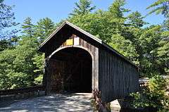
Babb's Bridge
|
Babb's Bridge | |
|
Babb's Bridge in September 2014 | |
  | |
| Nearest city | Gorham, Maine/Windham, Maine |
|---|---|
| Coordinates | 43°45′58″N 70°26′53″W / 43.76611°N 70.44806°WCoordinates: 43°45′58″N 70°26′53″W / 43.76611°N 70.44806°W |
| Area | less than one acre |
| Built | 1843 |
| NRHP Reference # | 09000088[1] |
| Added to NRHP | September 7, 1972 |
Babb's Bridge is a covered bridge spanning the Presumpscot River on Hurricane Road, between the towns of Gorham and Windham in Cumberland County, Maine. Built in 1976, it is a replica of a 19th-century bridge that stood on the site until destroyed by fire in 1973. The 1973 bridge was listed on the National Register of Historic Places in 1972.[1]
Description and history
Babb's Bridge is located on the Presumpscot River, carrying Hurricane Road between central-western Windham on the east side and northern Gorham on the west side. It is a single-span queenspost truss bridge, with a total structure length of 79 feet (24 m) and a width of 13 feet 9 inches (4.19 m). Its end portals have a posted height limit of 10 feet (3.0 m). It is covered by a gabled roof, and its side and end walls are finished in vertical board siding.[2]
The present bridge is a reconstruction, dedicated in 1976, of an earlier bridge, which was destroyed by arson in 1973. The exact date of construction of the older bridge is a matter of debate. Some sources give a date as early as 1843, while the state and other sources maintain a date of 1864. The 19th-century bridge was listed on the National Register of Historic Places in 1972 as a joint effort of the Windham and Gorham Historical Societies. Following its destruction, the towns petitioned the state to build a replica, instead of replacing the bridge with a modern structure of steel and concrete. The present bridge was built, in part as a community effort with donated materials and labor, using techniques that might have been used in the construction of the original.[2]
In 2014, vandals cut holes in its roof to allow people to jump into the river below.[3]
See also
- National Register of Historic Places listings in Cumberland County, Maine
- List of bridges on the National Register of Historic Places in Maine
- List of Maine covered bridges
References
- 1 2 National Park Service (2010-07-09). "National Register Information System". National Register of Historic Places. National Park Service.
- 1 2 Evans, Benjamin; Evans, June (2012). New England's Covered Bridges: A Complete Guide. UPNE. pp. 36–37. ISBN 9781611683851.
- ↑ Pelletier, Jared (September 16, 2014). "Vandals cut holes in roof of landmark covered bridge in Windham". Bangor Daily News. WGME. Retrieved 23 November 2014.
