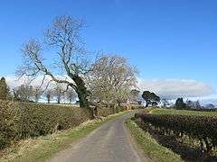
Bairnkine
Coordinates: 55°26′07″N 2°32′57″W / 55.43530°N 2.54916°W
Bairnkine is a hamlet on the Jed Water in the Scottish Borders area of Scotland, on the A68, south of Jedburgh.
Other places nearby include Abbotrule, Bedrule, Camptown, Chesters, Langlee, Mervinslaw and Oxnam.
See also
External links
| Wikimedia Commons has media related to Bairnkine. |
- RCAHMS record for Bairnkine
- GEOGRAPH image: New plantation at Bairnkine
- STREETMAP: Bairnkine
- Aerial photos of Bairnkine
This article is issued from Wikipedia - version of the 10/24/2016. The text is available under the Creative Commons Attribution/Share Alike but additional terms may apply for the media files.

