Baix Empordà
| Baix Empordà | |
|---|---|
| Comarca | |
 | |
| Country |
|
| Autonomous community |
|
| Province | Girona |
| Capital | La Bisbal d'Empordà |
| Municipalities |
List
|
| Area | |
| • Total | 701.8 km2 (271.0 sq mi) |
| Population (2014) | |
| • Total | 132,886 |
| • Density | 190/km2 (490/sq mi) |
| Demonym(s) | Baixempordanès |
| Time zone | CET (UTC+1) |
| • Summer (DST) | CEST (UTC+2) |
| Largest municipality | Palafrugell |
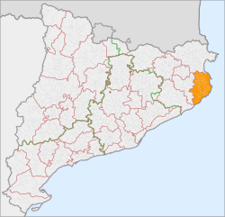
Baix Empordà (Catalan pronunciation: [ˈbaʒ əmpurˈða], "Lower Empordà") is a comarca (county) in Catalonia, Spain, one of the two into which Empordà was divided in the comarcal division of 1936, the other one being Alt Empordà. It is popularly known as L'Empordanet ("the Little Empordà").
Geography
Baix Empordà is the southern portion of the historical region of Empordà. It includes the municipalities between the Montgrí Massif, just north of the river Ter, and the Aro valley, in the south. It totals 37 municipalities, with a total area of 700,5 km2. It borders Alt Empordà to the north, Gironès and Selva to the west and the Mediterranean Sea to the east.
Municipalities
| Municipality | Population(2014)[1] | Areakm2[1] |
|---|---|---|
| Albons | 727 | 11.1 |
| Begur | 3,994 | 20.7 |
| Bellcaire d'Empordà | 650 | 12.6 |
| La Bisbal d'Empordà | 10,761 | 20.6 |
| Calonge | 10,541 | 33.6 |
| Castell-Platja d'Aro | 10,721 | 21.8 |
| Colomers | 195 | 4.4 |
| Corçà | 1,257 | 16.3 |
| Cruïlles, Monells i Sant Sadurní de l'Heura | 1,284 | 99.8 |
| Foixà | 320 | 18.8 |
| Fontanilles | 160 | 9.3 |
| Forallac | 1,729 | 50.6 |
| Garrigoles | 159 | 9.4 |
| Gualta | 362 | 9.0 |
| Jafre | 396 | 6.6 |
| Mont-ras | 1,739 | 12.3 |
| Palafrugell | 22,763 | 26.9 |
| Palamós | 17,805 | 14.0 |
| Palau-sator | 305 | 12.4 |
| Pals | 2,533 | 25.8 |
| Parlavà | 410 | 6.2 |
| La Pera | 467 | 11.5 |
| Regencós | 291 | 6.3 |
| Rupià | 246 | 5.3 |
| Sant Feliu de Guíxols | 21,810 | 16.2 |
| Santa Cristina d'Aro | 5,194 | 67.6 |
| Serra de Daró | 211 | 7.9 |
| La Tallada d'Empordà | 454 | 16.6 |
| Torrent | 170 | 8.0 |
| Torroella de Montgrí | 11,381 | 65.9 |
| Ullà | 1,053 | 7.3 |
| Ullastret | 289 | 11.1 |
| Ultramort | 204 | 4.4 |
| Vall-llobrega | 901 | 5.4 |
| Verges | 1,195 | 9.7 |
| Vilopriu | 209 | 16.4 |
| • Total: 36 | 132,886 | 701.8 |
References
- 1 2 "El municipi en xifres". Institut d'Estadística de Catalunya. Retrieved 2015-05-25.
External links
| Wikimedia Commons has media related to Costa Brava. |
- Official comarcal web site (in Catalan)
- Tourist comarcal web site
- Miscellaneous related information on the web site of the Generalitat de Catalunya (in Catalan)
 |
Alt Empordà |  | ||
| Gironès | |
Mediterranean Sea | ||
| ||||
| | ||||
| Selva | Balearic Sea |
Coordinates: 41°56′42″N 3°03′36″E / 41.94500°N 3.06000°E
This article is issued from Wikipedia - version of the 10/1/2015. The text is available under the Creative Commons Attribution/Share Alike but additional terms may apply for the media files.