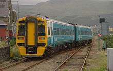
Barmouth railway station
| Barmouth | |
|---|---|
| Welsh: Abermaw | |
 | |
| Location | |
| Place | Barmouth |
| Local authority | Gwynedd |
| Grid reference | SH612158 |
| Operations | |
| Station code | BRM |
| Managed by | Arriva Trains Wales |
| Number of platforms | 2 |
| DfT category | E |
|
Live arrivals/departures, station information and onward connections from National Rail Enquiries | |
| Annual rail passenger usage* | |
| 2010/11 |
|
| 2011/12 |
|
| 2012/13 |
|
| 2013/14 |
|
| 2014/15 |
|
| History | |
| Key dates | Opened 1867 |
| National Rail – UK railway stations | |
| * Annual estimated passenger usage based on sales of tickets in stated financial year(s) which end or originate at Barmouth from Office of Rail and Road statistics. Methodology may vary year on year. | |
|
| |
Barmouth railway station serves the seaside town of Barmouth in Gwynedd, Wales. The station is on the Cambrian Coast Railway with passenger services to Harlech, Porthmadog, Pwllheli, Tywyn, Aberdovey, Machynlleth and Shrewsbury. Between Morfa Mawddach and Barmouth the railway crosses the Afon Mawddach on the famous Barmouth Bridge.
History
The station (opened in 1867) originally extended further south, with a platform for trains to Dolgellau and Ruabon on the south side of the level crossing. This platform became disused following the closure of the Dolgellau line in 1965, but remained in situ with its waiting room until the early 1990s. It was demolished to make way for a bus stop and car park. The goods yard was redeveloped around the same time by Co-operative Retail Services and, as at Tywyn and Pwllheli, is now occupied by a supermarket.
Until the 1960s there was a summer service between London Paddington and Pwllheli, via Birmingham Snow Hill, Shrewsbury and Machynlleth.
The station signal box, also on the south side of the level crossing, became disused in the 1980s as the Cambrian Line's traditional signalling system was replaced with radio signalling (RETB). After lying derelict for several years, it was moved to Glyndyfrdwy on the preserved Llangollen Railway.
Facilities
The southbound platform was improved in 2003 and is now home to Barmouth's tourist information centre. The station is unstaffed, but the tourist information centre provides a travel information service. The building also houses a small museum devoted to the history of Barmouth.
Services
Trains operate every two hours in each direction, southbound to Machynlleth, Shrewsbury & Birmingham International and northbound to Pwllheli (a limited number also originate or terminate here). On Sundays, there is a single service each way all year, with extra trains in the summer.[1] All services at Barmouth are provided by Arriva Trains Wales using its Class 158 DMUs.
From 3 January 2014, train services were suspended due to major infrastructure damage at several locations along the line caused by storm-force winds and the resultant tidal surges. Part of the sea wall to the north near Llanaber was swept away, leading to severe damage to the formation which closed the line for 5 months, whilst further south a section of embankment at Tonfannau was washed out. Network Rail restored service to Barmouth from the south on 10 February 2014, and the line as far north as Harlech in May the same year.[2] The northern end of the route beyond Harlech remained closed until 1 September 2014 due to the reconstruction of the Pont Briwet viaduct.
Gallery
-

Arriva Trains Wales 158823 departs for Birmingham International.
-

Barmouth Station in 1962
-

A double-headed return holiday express in 1962
-

Train from Chester in 1962
References
- ↑ Table 76 National Rail timetable, May 2016
- ↑ "Section of Cambrian Coast line damaged by ferocious storms to reopen in May ahead of schedule"Wales Online article 21 March 2014; Retrieved 12 October 2016
External links
| Wikimedia Commons has media related to Barmouth railway station. |
- Train times and station information for Barmouth railway station from National Rail
| Preceding station | Following station | |||
|---|---|---|---|---|
| Arriva Trains Wales | ||||
| Historical railways | ||||
Line and station open | Great Western Railway | Line and station open |
||
Line and station open | Great Western Railway | Terminus | ||
Coordinates: 52°43′23″N 4°03′25″W / 52.723°N 4.057°W