Barrhead Branch
| Barrhead Branch | ||||||||||||||||||||||||||||||||||||||||||||||||||||||||||||||||||||||||||||||||||||||||||||||||||||||||||||||||||||||||||||||||||||||||||||||||||||||||||||||||||||||||||||||||||
|---|---|---|---|---|---|---|---|---|---|---|---|---|---|---|---|---|---|---|---|---|---|---|---|---|---|---|---|---|---|---|---|---|---|---|---|---|---|---|---|---|---|---|---|---|---|---|---|---|---|---|---|---|---|---|---|---|---|---|---|---|---|---|---|---|---|---|---|---|---|---|---|---|---|---|---|---|---|---|---|---|---|---|---|---|---|---|---|---|---|---|---|---|---|---|---|---|---|---|---|---|---|---|---|---|---|---|---|---|---|---|---|---|---|---|---|---|---|---|---|---|---|---|---|---|---|---|---|---|---|---|---|---|---|---|---|---|---|---|---|---|---|---|---|---|---|---|---|---|---|---|---|---|---|---|---|---|---|---|---|---|---|---|---|---|---|---|---|---|---|---|---|---|---|---|---|---|---|---|
| ||||||||||||||||||||||||||||||||||||||||||||||||||||||||||||||||||||||||||||||||||||||||||||||||||||||||||||||||||||||||||||||||||||||||||||||||||||||||||||||||||||||||||||||||||
Legend | ||||||||||||||||||||||||||||||||||||||||||||||||||||||||||||||||||||||||||||||||||||||||||||||||||||||||||||||||||||||||||||||||||||||||||||||||||||||||||||||||||||||||||||||||||
| ||||||||||||||||||||||||||||||||||||||||||||||||||||||||||||||||||||||||||||||||||||||||||||||||||||||||||||||||||||||||||||||||||||||||||||||||||||||||||||||||||||||||||||||||||
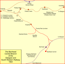
The Barrhead Branch was a branch line built by the Glasgow and South Western Railway in Scotland. It connected Potterhill railway station on the south side of Paisley with a new Barrhead Central railway station. The line was sometimes known as the Barrhead Central Railway.
It was made in reaction to competition for local passenger traffic, and for a time a circular service operated from Glasgow via Paisley and Barrhead. However income from the line was disappointing, and the passenger service was cut back, finally closing in 1917. As a goods-only route it remained open until 1970. None of the line is open now.
History

Towards the end of the nineteenth century, the Directors of the Glasgow and South Western Railway (G&SWR) realised that the emphasis for suburban passengers had moved away from infrequent services to main population centres. Moreover, in urban area, new competition was arising from omnibus services and street tramways. They responded by planning frequent services on suburban routes, calling at new stations close to developing industrial sites.
In 1885 the Paisley Canal Line opened, with stations on the south side of Paisley, and in 1886 a short branch southwards to Potterhill was opened. For the time being this remained a terminus.[1][2]
There was bitter rivalry between the G&SWR and the Caledonian Railway (CR); both companies had a presence at both Paisley and Barrhead, and in 1897 the CR obtained Parliamentary authority to build the Paisley and Barrhead District Railway, serving the district between the two towns.
The G&SWR had a Barrhead station on the Glasgow, Barrhead and Kilmarnock Joint Railway (GB&KJR) but the station there was inconveniently located, and on 19 August 1898 the G&SWR obtained an Act of Parliament for a number of developments, including an extension of the line from Potterhill to a new central station at Barrhead, with a spur to join the GB&KJR, facing Glasgow.[3]
The line opened on 1 October 1902; the new Barrhead station was named Barrhead Central. A circular passenger service was operated from Glasgow St Enoch via Paisley, Potterhill, Barrhead Central and Nitshill; the anti-clockwise service was described as the inner circle and the other direction was the outer circle.[2] Barrhead Central was a terminus, and the circular service involved a reversal there.
While the more frequent service found some success in the Glasgow and Paisley urban areas, competing against omnibuses and street tramways, patronage on the more rural area between Barrhead and Paisley was disappointing. On 1 October 1907 the circular passenger service was discontinued, and trains worked from St Enoch to Barrhead Central via Paisley and Potterhill, and separately from St Enoch to Barrhead Central via Nitshill. The line between Potterhill and Barrhead Central was closed to passenger services on 1 June 1913 . Operation of these services did not pay, and on 1 January 1917 under the stress of World War I conditions, both Potterhill and Barrhead Central stations were closed to passengers.[2]
The through line continued in use for goods services, and a factory for the confectionery manufacturer Cadbury was established with a private siding connection.[4] The line closed to all traffic on 2 March 1970.
Railtour in 1951
A rail tour operated by the Stephenson Locomotive Society ran on the line on 1 September 1951.[5][6] The train started at Paisley East Goods on the Paisley and Barrhead District Railway at Cecil Street and ran to Barrhead South. It then travelled via Elderslie and Johnstone to Paisley West, and from there to the goods station at Gleniffer Depot on the Barrhead Branch.[7]
Topography

The line started at Potterhill railway station, which had opened in 1886 on a branch from the Paisley Canal Line. The line ran approximately south-east; shortly there was a facing junction, Thornly Park Junction, where the short Gleniffer Branch diverged, turning south and then west to serve the Glenfield works of Fulton Textile Mills; this closed in 1966.[4] Approaching the GB&KJR main line, the branch turned south-west to cross under the GB&KJR, reaching Barrhead Central station terminus, lying south-east of the main line. A north to east spur gave access for goods trains from Potterhill towards Glasgow, and a connection from Barrhead Central station also gave access in that direction.
When the Caledonian Railway opened its Paisley and Barrhead District Railway line in 1902, it ran very close to the Barrhead Central Line, crossing over it in two places.
The Barrhead Central Railway opened from Potterhill to Glenfield Works on 21 August 1899, for goods only. It was extended to Barrhead Central and open for all traffic on 1 October 1902. The north to east spur at Barrhill closed in 1910, and the section between Potterhill and Barrhead Central closed to passengers on 1 June 1913. Barrhead Central station was closed to passengers on 1 January 1917.[8][9][10]
References
- ↑ David Ross, The Glasgow and South Western Railway: A History, Stenlake Publishing Limited, Catrine, 2104, ISBN 978 1 84033 648 1
- 1 2 3 Stephenson Locomotive Society, The Glasgow and South Western Railway, 1850 - 1923, published by the SLS, London, 1950
- ↑ Ross, page 143
- 1 2 Wham
- ↑ Seller and Stevenson
- ↑ "Photographs of only passenger train journey in 1951". Archived from the original on 1 October 2007. Retrieved 2007-10-06.
- ↑ The Railway Magazine
- ↑ Campbell Highet, The Glasgow & South-Western Railway, Oakwood Press, Lingfield, 1965
- ↑ M E Quick, Railway Passenger Stations in England Scotland and Wales—A Chronology, The Railway and Canal Historical Society, 2002
- ↑ Col M H Cobb, The Railways of Great Britain -- A Historical Atlas, Ian Allan Publishing Limited, Shepperton, 2003, ISBN 07110 3003 0
Sources
- Butt, R. V. J. (1995). The Directory of Railway Stations: details every public and private passenger station, halt, platform and stopping place, past and present (1st ed.). Sparkford: Patrick Stephens Ltd. ISBN 1-8526-0508-1. OCLC 60251199.
- Gammell, C.J. (1999). Scottish branch lines. Shepperton: Oxford Publishing Co. ISBN 0-8609-3540-X. OCLC 44398793.
- Jowett, Alan (March 1989). Jowett's Railway Atlas of Great Britain and Ireland: From Pre-Grouping to the Present Day (1st ed.). Sparkford: Patrick Stephens Ltd. ISBN 1-8526-0086-1. OCLC 22311137.
- Seller, W. S.; Stevenson, J. L. (1980). The Last Trains, Volume 2: Glasgow & Central Scotland. Edinburgh: Moorfoot Publishing. ISBN 0-9066-0602-0. OCLC 25917538.
- Stansfield, G. (1999). Ayrshire & Renfrewshire's Lost Railways. Ochiltree: Stenlake Publishing. ISBN 1-8403-3077-5.
- The Railway Magazine Nov 1951 issue page 784
- Wham, Alasdair (2000). The Lost Railway Lines South of Glasgow. Wigtown: G.C. Book Publishers. ISBN 1-8723-5008-9.
- Railscot on the G&SWR Barrhead Branch
- Barrhead Branch web page with Google satellite images, past and current and photographs
- Google satellite image - curve around Meikleriggs Cricket Ground (top left) to Potterhill Station near former Cadbury's factory at Neilston Road
- Google satellite image - Curve from Potterhill Line into Gleniffer depot - PBDR line from Glenfield station can also be seen crossing it