Basalt Lake
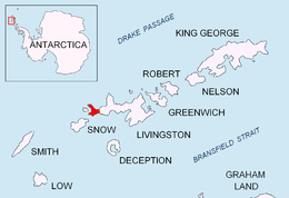
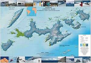
Basalt Lake is a small freshwater lake surrounded by three basalt outcrops with ‘organ-pipe’ formations in their rocks, situated in the central part of the ice-free Byers Peninsula, Livingston Island in the South Shetland Islands, Antarctica. and draining through a 1.6 km stream southwards into Bransfield Strait.
The feature is descriptively named from the surrounding rock formations.
Location
Basalt Lake is centred at 62°38′35″S 61°03′33.7″W / 62.64306°S 61.059361°W which is 4.07 km northeast of Sealer Hill, 1.85 km east of Usnea Plug, 1.5 km east-southeast of Chester Cone, 3.02 km west-southwest of Tsamblak Hill and 3.22 km west-northwest from Negro Hill (British mapping in 1968, detailed Spanish mapping in 1992, and Bulgarian mapping in 2005 and 2009).
Map
- Península Byers, Isla Livingston. Mapa topográfico a escala 1:25000. Madrid: Servicio Geográfico del Ejército, 1992.
- L.L. Ivanov et al. Antarctica: Livingston Island and Greenwich Island, South Shetland Islands. Scale 1:100000 topographic map. Sofia: Antarctic Place-names Commission of Bulgaria, 2005.
- L.L. Ivanov. Antarctica: Livingston Island and Greenwich, Robert, Snow and Smith Islands. Scale 1:120000 topographic map. Troyan: Manfred Wörner Foundation, 2009. ISBN 978-954-92032-6-4