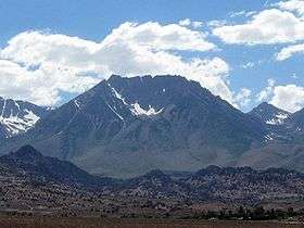
Basin Mountain (California)
| Basin Mountain | |
|---|---|
 Basin Mountain's east face in summer | |
| Highest point | |
| Elevation | 13187+ ft (4020+ m) NAVD 88[1] |
| Prominence | 421 ft (128 m) [1] |
| Listing | Sierra Peaks Section[2] |
| Coordinates | 37°17′50″N 118°39′31″W / 37.2971555°N 118.6587268°WCoordinates: 37°17′50″N 118°39′31″W / 37.2971555°N 118.6587268°W [3] |
| Geography | |
 Basin Mountain
| |
| Location | Inyo County California, U.S. |
| Parent range | Sierra Nevada |
| Topo map | USGS Mount Tom |
| Climbing | |
| First ascent | November 9, 1930, by Norman Clyde via the North Slope[4] |
| Easiest route | Scramble, class 2 via the North Slope[4] |
Basin Mountain in California's eastern Sierra Nevada range is a large and visually prominent peak near the city of Bishop. Basin Mountain is not as high as its neighboring peaks, Mount Tom and Mount Humphreys, but it dominates the view to the west from Bishop as it rises above the Buttermilks. It is a relatively easy scramble to the top. The summit is not especially notable, except for the wonderful views it offers of Mount Tom, which dominates the skyline just to the north. The night-time views of Bishop and the Owens valley are spectacular.
See also
References
- 1 2 "Basin Mountain, California". Peakbagger.com. Retrieved 2009-06-21.
- ↑ "Sierra Peaks Section List" (PDF). Angeles Chapter, Sierra Club. Retrieved 2009-06-21.
- ↑ "Basin Mountain". Geographic Names Information System. United States Geological Survey. Retrieved 2009-06-21.
- 1 2 Secor, R.J. (2009). The High Sierra Peaks, Passes, and Trails (3rd ed.). Seattle: The Mountaineers. p. 325. ISBN 9780898869712.
External links
- "Basin Mountain". SummitPost.org. Retrieved 2011-05-26.
This article is issued from Wikipedia - version of the 3/22/2016. The text is available under the Creative Commons Attribution/Share Alike but additional terms may apply for the media files.