Battambang District
| Battambang ស្រុកបាត់ដំបង | |
|---|---|
| District (srok) | |
 | |
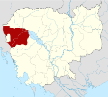
 Battambang Location in Cambodia | |
| Coordinates: 13°5′N 103°5′E / 13.083°N 103.083°E | |
| Country |
|
| Province | Battambang |
| Communes | 10 |
| Population (1998)[1] | |
| • Total | 116,793 |
| Time zone | +7 |
Battambang District (Khmer: ស្រុកបាត់ដំបង) (often Bat Dambang) is a district (srok) of Battambang Province, in north-western Cambodia. The capital lies at Battambang city.
Administration
The district is subdivided into 10 communes (khum).[2]
Communes and villages
| Khum (Commune) | Phum (Villages) |
|---|---|
| Tuol Ta Aek | Ou Ta Kam Muoy, Ou Ta Kam Pir, Ou Ta Kam Bei, Tuol Ta Aek, Dangkao Teab |
| Preaek Preah Sdach | Preaek Preah Sdach, Preaek Ta Tan, Dabbei Meakkakra, Ou Khcheay, La Edth, Num Krieb, Baek Chan Thmei, Chamkar Ruessei |
| Rotanak | Rumchek Muoy, Rumchek Pir, Rumchek Bei, Rumchek Buon, Rumchek Pram, Souphi Muoy, Souphi Pir, Rotanak |
| Chamkar Samraong | Chamkar Samraong Muoy, Chamkar Samraong Pir, Voat Lieb, Voat Rumduol, Phka Sla |
| Sla Kaet | Sla Kaet, Dam Spey, Chrey Kaong |
| Kdol Doun Teav | Chong Preaek, Kdol, Ou Ta Nob, Ta Pruoch, Ta Koy, Kantuot, Thkov |
| Ou Mal | Ou Mal, Dak Sasar, Sala Balat, Prey Dach, Kouk Ponley, Voat Roka, Koun Sek, Andoung Pring, Boeng Reang, Prey Roka |
| Voat Kor | Voat Kor, Chrab Krasang, Ballang, Khsach Pouy, Damnak Luong, Kampong Seima |
| Ou Char | Ou Char, Prey Koun Sek, Kab Kou Thmei, Andoung Chenh, Anhchanh, Ang |
| Svay Pao | Preaek Moha Tep, Kampong Krabei, Mphey Osakphea, Kammeakkar |
References
- ↑ General Population Census of Cambodia, 1998: Village Gazetteer. National Institute of Statistics. February 2000. pp. 1–4.
- ↑ Statistics of the Cambodian Government Archived December 24, 2008, at the Wayback Machine.
Coordinates: 13°5′N 103°5′E / 13.083°N 103.083°E
This article is issued from Wikipedia - version of the 11/17/2016. The text is available under the Creative Commons Attribution/Share Alike but additional terms may apply for the media files.
