Baula
| Baula | |
|---|---|
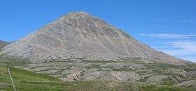
 Baula, July 2006 | |
| Highest point | |
| Elevation | 934 m (3,064 ft) |
| Coordinates | 64°53′N 21°24′W / 64.883°N 21.400°WCoordinates: 64°53′N 21°24′W / 64.883°N 21.400°W |
| Geography | |
 Baula | |
| Geology | |
| Age of rock | 3.5 million years |
| Mountain type | Batholith |
| Last eruption | 3.5 million years ago |
The mountain Baula, with its reddish or orange colour caused by its rhyolite rock composition, is situated in the west of Iceland next to Route 1 (the Ring Road). Bifröst University and the picturesque craters of Grábrók are located nearby.

Geologically, the mountain is classified as an "intrusion" (or, in geologist's terms, a "batholith," which is a mass of rock that has been thrust upwards from deep within the earth, to the surface).
Baula is characterized by its almost perfect cone and by its little sister nearby, the Litla-Baula, where rare columnar strands of rhyolite are found. Together, Baula and Litla-Baula have often been described as Iceland's most beautiful pair of mountains.
Some other good examples of similar "intrusions" in Iceland include the mountains Mælifell in the Snæfellsnes Peninsula and the Hlíðarfjall, near lake Mývatn in the north of the country.
References
- Björn Hróarsson, Á ferð um landið, Borgarfjörður og Mýrar, Mál og menning (1994) ISBN 9979-3-0657-2