Baulne
| Baulne | ||
|---|---|---|
|
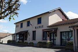
The town hall of Baulme | ||
| ||
 Baulne | ||
|
Location within Île-de-France region  Baulne | ||
| Coordinates: 48°29′32″N 2°21′35″E / 48.4923°N 2.3596°ECoordinates: 48°29′32″N 2°21′35″E / 48.4923°N 2.3596°E | ||
| Country | France | |
| Region | Île-de-France | |
| Department | Essonne | |
| Arrondissement | Étampes | |
| Canton | La Ferté-Alais | |
| Intercommunality | Val d'Essonne | |
| Government | ||
| • Mayor (2008–2014) | Jacques Bernard | |
| Area1 | 8.17 km2 (3.15 sq mi) | |
| Population (2006)2 | 1,375 | |
| • Density | 170/km2 (440/sq mi) | |
| Time zone | CET (UTC+1) | |
| • Summer (DST) | CEST (UTC+2) | |
| INSEE/Postal code | 91047 / 91590 | |
| Elevation | 49–144 m (161–472 ft) | |
|
1 French Land Register data, which excludes lakes, ponds, glaciers > 1 km² (0.386 sq mi or 247 acres) and river estuaries. 2 Population without double counting: residents of multiple communes (e.g., students and military personnel) only counted once. | ||
Baulne is a commune in the Essonne department in Île-de-France in northern France. Inhabitants of Baulne are known as Baulnois.
Origin of the village name
The origin of the name Baulne is not well known. It was created under the same name as it is today.
Geographical situation
It is 52km south of Paris Notre Dame, point zero from roads of France, 17 kilometers south east of Évry, 16 kilometers north east of Étampes, 1 kilometer north of La Ferté-Alais, 13 kilometers south east of Arpajon, 13 kilometers north west of Milly-la-Forêt,16 kilometers south east of Corbeil-Essonnes, 18 kilometers south east of Montlhéry, 26 kilometers south east of Palaiseau, 26 kilometers east of Dourdan. It is 107 kilometers away from its homonym Baulne-en-Brie in the department of Aisne.
See also
References
- Mayors of Essonne Association (French)
External links
| Wikimedia Commons has media related to Baulne. |
- Mérimée database - Cultural heritage (French)
- Land use (IAURIF) (English)

.svg.png)