Bielsdown River
| Bielsdown River | |
| Bielsdown Creek[1] | |
| Perennial stream | |
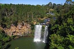
 Dangar Falls on the Bielsdown River. | |
| Country | Australia |
|---|---|
| State | New South Wales |
| IBRA | NSW North Coast |
| District | Northern Tablelands |
| Municipality | Bellingen |
| Part of | Clarence River catchment |
| Tributaries | |
| - right | Rocky Creek (New South Wales) |
| Source | Dorrigo Plateau, Great Dividing Range |
| - location | west of Dorrigo |
| - elevation | 936 m (3,071 ft) |
| Mouth | confluence with the Nymboida River |
| - location | west of Cascade |
| - elevation | 477 m (1,565 ft) |
| Length | 38 km (24 mi) |
| Waterfall | Dangar Falls |
| [2] | |
Bielsdown River, a perennial stream[1] that is part of the Clarence River catchment, is located in the Northern Tablelands of New South Wales, Australia.
Course
Bielsdown River rises on the Dorrigo Plateau within the Great Dividing Range, below Fernbrook, west of Dorrigo, and flows generally to the north and northeast, joined by one minor tributary towards its confluence with Nymboida River, west of Cascade. The river descends 459 metres (1,506 ft) over its 38 kilometres (24 mi) course.[2]
About 1.2 kilometres (0.75 mi) north of Dorrigo, the river descends downs Dangar Falls.[3] The falls are small but picturesque, and are a popular photographic subject.[4]
See also
References
- 1 2 "Bielsdown River". Geographical Names Register (GNR) of NSW. Geographical Names Board of New South Wales. Retrieved 28 February 2013.
- 1 2 "Bielsdown River, NSW". Bonzle Digital Atlas of Australia. Retrieved 27 February 2013.
- ↑ "Dangar Falls". Geographical Names Register (GNR) of NSW. Geographical Names Board of New South Wales. Retrieved 29 June 2009.
- ↑ "Dangar Falls". Stevografix. Retrieved 30 June 2009.
Coordinates: 30°19′S 152°44′E / 30.317°S 152.733°E
This article is issued from Wikipedia - version of the 5/3/2016. The text is available under the Creative Commons Attribution/Share Alike but additional terms may apply for the media files.