Boelenslaan
| Boelenslaan | |||
|---|---|---|---|
| Village | |||
| |||
 Boelenslaan Location within the Netherlands | |||
| Coordinates: 53°09′43″N 06°08′41″E / 53.16194°N 6.14472°E | |||
| Country |
| ||
| Province |
| ||
| Population | |||
| • Total | c. 1,200 | ||
| Time zone | CET (UTC+1) | ||
| • Summer (DST) | CEST (UTC+2) | ||
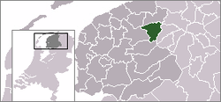
Boelenslaan (West Frisian: Boelensloane) is a small town in Achtkarspelen municipality in Friesland province in the northern Netherlands.
Boelenslaan has 1186 inhabitants and is named from its founder Mr. Boelens, after whom it was named. "Laan" - avenue; the road through the village used to be a sandy road and is still bearing the name Boelenswei ("wei" being the West Frisian word for "road".
History
The village was founded in the 19th century. The houses used to belong to Surhuisterveen, on the "Feanster heide". Boelenslaan owed its foundation to peat-digging; the payment was poor and the citizens were known to be "red" - socialist. The poor people lived in "plaggenhutten", later in "wâldhûskes" which were small Dutch cottages.
The village is in the "Friese Wouden" in the Frisian forests.
The Flag of Boelenslaan
The color red refers to the heathland and the severability fight of the population, the color yellow refers to the Sandgrounds. The color green refers to Friese Wouden, from the village area. The silver rose is the coat of arms of the noble family Boelens, after whom it was named.[1]
References
- ↑ friesland-digitaal.eu In Dutch language, about the history of Boelenslaan
External links
![]() Media related to Boelenslaan at Wikimedia Commons
Media related to Boelenslaan at Wikimedia Commons
Coordinates: 53°10′N 6°09′E / 53.167°N 6.150°E


