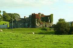
Burneside Hall
| Burneside Hall | |
|---|---|
| Cumbria, England | |
|
The ruined pele tower | |
 Burneside Hall | |
| Coordinates | grid reference SD509959 |
| Type | Pele tower |
| Site information | |
| Owner | private |
| Open to the public | No |
| Condition | Ruined |
Burneside Hall is a converted medieval pele tower in Burneside, Cumbria, England.
History
Documentary records for Burneside Hall extend to 1290, when a property was owned on the site by Gilbert Burneshead, the Under-Sheriff of Westmorland.[1] Richard Bellingham, a member of an influential Northumberland family, married Burneshead's daughter, acquiring the site.[2] Burneside Hall in its current form was originally built in the second half of the 14th century by the Bellingham family.[3] The medieval heart of Burneside Hall was a pair of pele towers, linked by a large, open hall.[4] Only one of these towers still remains, three storeys tall but badly ruined, measuring 20 feet by 35 feet (6 metres by 11 metres).[5] This tower was originally the buttery and pantry, forming the service end of the castle.[6] The second tower was of similar height to the first, but narrower; it was rebuilt in the 18th century and effectively destroyed.[7]
The Bellinghams remained the owners until Burnaldeshede 'Castle' was seized by the King in 1461, when Henry Bellingham was attanted for treason, and it was held by the Parr family until Bellingham's general pardon in 1480. During the 1530s it was sold by the Bellinghams to Sir Thomas Clifford, and passed from him to John Fitzwilliam, who in 1552 sold it to John Machell of Kendal and London (Sheriff of London 1555-6).[8] His heirs sold it to the Braithwaite family, who retained it for the next seven generations.[9] During the early 17th century it was the home of the poet Richard Brathwaite.[10] A two-storey gatehouse at the front of the property was built in the late-16th or 17th century, with a relatively substantial barmkin wall, 6 feet (2 metres) thick in places, erected around it.[11] The original open hall was converted into smaller rooms in the 17th century, and additional windows added.[12] The second tower was rebuilt in the 18th century and effectively destroyed in the process.[13] In the late 19th-century, Stephen Brunskill inherited the property and conducted some restoration work on the medieval parts of the property.[14]
Today
Burneside Hall is a Grade II* listed building and scheduled monument; as of 2014, English Heritage considered the Burnside Hall pele tower to be formally at risk of slow decay.[15]
The Hall is part of a working tenanted farm.
See also
Bibliography
- Emery, Anthony. (1996) Greater Medieval Houses of England and Wales, 1300-1500: Northern England. Cambridge: Cambridge University Press. ISBN 978-0-521-49723-7.
- Jones, Thomas. (1912) The History of Burneside. Kendal, UK: Atkinson and Politt.
- Pettifer, Adrian. (2002) English Castles: a Guide by Counties. Woodbridge, UK: Boydell Press. ISBN 978-0-85115-782-5.
References
- ↑ Jones, p.5.
- ↑ Jones, p.6.
- ↑ Emery, p.198.
- ↑ Emery, p.197; Pettifer, p.268.
- ↑ Emery, p.197.
- ↑ Pettifer, p.268.
- ↑ Emery, p.197.
- ↑ William Farrer & John F. Curwen (editors), 'Strickland Roger', Records relating to the Barony of Kendale: volume 1 (1923), pp. 265-275.
- ↑ Jones, p.6., reciting from Sir Daniel Fleming of Rydal's MS "Description of the County of Westmorland AD 1671" (Bodleian), see Sir George Floyd Duckett (ed.), Cumberland and Westmorland Antiquarian and Archaeological Society, Tract Series Vol. I (London 1882), pp. 13-14.
- ↑
 Gosse, Edmund (1886). "Brathwaite, Richard". In Stephen, Leslie. Dictionary of National Biography. 6. London: Smith, Elder & Co.
 - ↑ Emery, p.198; Pettifer, p.268.
- ↑ Emery, p.197.
- ↑ Emery, p.197.
- ↑ Jones, p.6.
- ↑ Heritage at Risk Register 2014 North West (PDF). English Heritage. p. 36. Retrieved 24 September 2015.
External links
- The memorial chapel of Sir Roger Bellingham (of Burneside, d. 1533) at Holy Trinity church, Kendal, with Bellingham Heraldry, now the memorial chapel of The Border Regiment.
Coordinates: 54°21′23″N 2°45′25″W / 54.3563°N 2.7570°W
