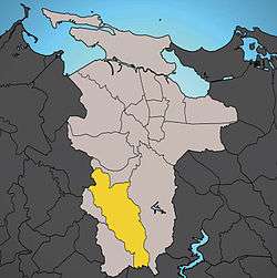
Caimito, San Juan, Puerto Rico
| Barrio of Caimito | |
|---|---|
 Location of Caimito shown in yellow. | |
| Country |
|
| Territory |
|
| Municipality | San Juan |
| Area | |
| • Total | 5.43 sq mi (14.06 km2) |
| • Land | 5.43 sq mi (14.06 km2) |
| • Water | 0.00 sq mi (0.00 km2) |
| Population (2000) | |
| • Total | 20,832 |
| • Density | 3,835.3/sq mi (1,480.82/km2) |
| 2000 census | |
With a land area of 5.43 square miles (14.06), Caimito is the second largest barrio in the municipality of San Juan, Puerto Rico. In the year 2000 it had 20,832 inhabitants and a population density of 3,835.3/sq mi (1,480.82/km2). Located in the south part of San Juan, Caimito is bordered by barrios Tortugo and Quebrada Arenas to the west, by Monacillo to the north, by Cupey to the east and by the municipality of Caguas to the south.
History
Caimito comprises the former barrios of Caimito Alto and Caimito Bajo, which were last documented in the 1899 census. It was part of Rio Piedras until 1951 when it was merged as a barrio of the municipality of San Juan.
Notable people
The noted boxing family, the Solis family, hails from Caimito.
- Enrique Solis- boxer, fought for world title
- Julian Solis- boxer, world champion
- Rafael Solis- boxer, fought for world title
- Santos Solis- professional boxer
| Historical population | ||
|---|---|---|
| Year | Pop. | ±% |
| 1899 | 1,706 | — |
| 1910 | 1,934 | +13.4% |
| 1920 | 2,329 | +20.4% |
| 1930 | 2,884 | +23.8% |
| 1935 | 3,473 | +20.4% |
| 1940 | 3,115 | −10.3% |
| 1950 | 4,588 | +47.3% |
| 1960 | 6,987 | +52.3% |
| 1970 | 13,268 | +89.9% |
| 1980 | 15,939 | +20.1% |
| 1990 | 19,413 | +21.8% |
| 2000 | 20,832 | +7.3% |
Coordinates: 18°20′14″N 66°04′18″W / 18.33722°N 66.07167°W