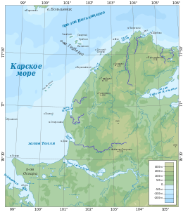
Cape Vega
| Cape Vega | |
|---|---|
| Мыс Вега | |
|
Map showing the location of Cape Vega | |
 | |
| Location |
Krasnoyarsk Krai, |
| Coordinates | 77°37′55″N 103°21′58″E / 77.6319444°N 103.3661111°ECoordinates: 77°37′55″N 103°21′58″E / 77.6319444°N 103.3661111°E |
| Offshore water bodies | Kara Sea |
| Area | Russian Far North |
Cape Vega (Russian: Мыс Вега; Mys Vega) is a headland on the northern shore of the Taymyr Peninsula in the Kara Sea, Russian Federation. This cape is located at the northern tip of the peninsula, a little to the west of Cape Chelyuskin. Oscar Bay lies between both capes.[1]
Administratively Cape Vega is part of the Taymyrsky Dolgano-Nenetsky District of Krasnoyarsk Krai.[2] It was named after Adolf Erik Nordenskiöld's ship SS Vega in which he carried out his Vega Expedition.[3]
This cape should not be confused with another headland named 'Cape Vega' in Taymyr Island.[4]
References
- ↑ GoogleEarth
- ↑ Geographical Names - Mys Vega: Russia
- ↑ The Voyage of the Vega Round Asia and Europe
- ↑ Prostar Sailing Directions 2005 North Coast of Russia Enroute, p. 115
External links
This article is issued from Wikipedia - version of the 11/14/2016. The text is available under the Creative Commons Attribution/Share Alike but additional terms may apply for the media files.
