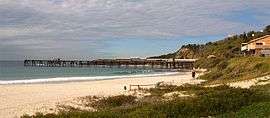
Catherine Hill Bay, New South Wales
| Catherine Hill Bay New South Wales | |||||||||||||
|---|---|---|---|---|---|---|---|---|---|---|---|---|---|
 Catherine Hill Bay coal loading wharf | |||||||||||||
| Population | 432 (2011 census)[1] | ||||||||||||
| • Density | 206/km2 (533/sq mi) | ||||||||||||
| Postcode(s) | 2281 | ||||||||||||
| Area | 2.1 km2 (0.8 sq mi) | ||||||||||||
| Location | 9 km (6 mi) S of Swansea | ||||||||||||
| LGA(s) | City of Lake Macquarie | ||||||||||||
| Parish | Wallarah | ||||||||||||
| State electorate(s) | Swansea | ||||||||||||
| Federal Division(s) | Shortland | ||||||||||||
| |||||||||||||
Catherine Hill Bay is a coastal bay and village on the southern peninsula forming Lake Macquarie, south of the Pacific Ocean entrance channel at Swansea in New South Wales, Australia. It is part of the City of Lake Macquarie local government area. The village is the oldest continuous settlement in the City of Lake Macquarie.
A surf club is sited overlooking the beach that is quite popular for recreation.
Mining
The settlement was first made after land was purchased on 1 April 1865. The town of Cowper was created, to serve as a base for coal mining by the New Wallsend Company in 1873 with the first shipment on 17 December of that year. The name Catherine Hill was adopted to commemorate the schooner Catherine Hill that had run aground in 1867.
Later, the Wallarah Coal Company mined and shipped coal from the area including its nearby Crangan Bay mine. This was taken over by the Coal and Allied Group.
A railway originally was used to transport the coal to the wharf;[2] later, trucks and automated loading belt systems were used.
Rutile was mined from the beach sands during the 1960s.
Development
Proposals for rezoning and redevelopment of the area for upmarket housing were opposed by residents, many of whom lived in older style and small miners' cottages, and by environmentalists, who contended that the heathlands around the village contained a large variety of wildflowers, some dwarfed into unusual forms from the exposed coastal conditions. On 1 September 2009, a court ruled the development agreement illegal.[3]
References
- ↑ Australian Bureau of Statistics (31 October 2012). "Catherine Hill Bay (State Suburb)". 2011 Census QuickStats. Retrieved 16 February 2014.
- ↑ Australian Railway Historical Society Bulletin, February 1973, pp25-44
- ↑ Moore, Matthew; Besser, Linton (1 September 2009). "ALP donor projects scuttled". Sydney Morning Herald. Retrieved 1 September 2009.
External links
- History of Catherine Hill Bay (Lake Macquarie City Library)
Coordinates: 33°08′53″S 151°37′05″E / 33.148°S 151.618°E