Caverswall
Caverswall is a village and parish in Staffordshire, to the south west of Staffordshire Moorlands. The population of the civil parish at the 2011 census was 971.[1]
Etymology
The name Caverswall is thought to have its origins in the Saxon words Cafhere, a personal noun, and Waelle, which meant spring or well.[2] By the time of the Domesday Book the village was called Caureswelle.
Around the Village
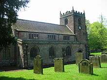
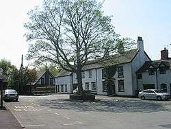
Near the village square are St Peter's Church of England Aided School, St. Peter's Church, St. Filumena's Catholic Church, St.Filumena's Primary School and a { now disused } Wesleyan Chapel. Also located on The Square is the Red House, a public house. In the middle of the square there is a large tree under which is a set of stocks.
Caverswall Castle may date from a Saxon manor house, but the fortifications date from a licence to crenellate (royal permission to fortify) granted in November 1275, although there may have been an earlier application in 1230. The castle remains were in-filled by a house in 1615, by Matthew Craddock from Stafford, and the former moat has been restored to encircle the castle.[3] It is privately owned.
Foxfield Railway is based approximately half a mile away from the village and runs heritage Steam Traction along the former Branch line to Foxfield Colliery.
References
- ↑ "Civil Parish population 2011". Retrieved 6 December 2015.
- ↑ Rogers, M J W (1994). Caverswall In Old Picture Postcards. European Library,Zaltbommel Netherlands. ISBN 90-288-5840-7.
- ↑ Davis, Philip (2007-11-13). "Caverswall Castle". The Gatehouse. Retrieved 2008-01-27.
External links
| Wikimedia Commons has media related to Caverswall. |
Coordinates: 52°59′00″N 2°04′28″W / 52.98342°N 2.07443°W
| Unitary authorities | |
|---|---|
| Boroughs or districts | |
| Major settlements | |
| Rivers | |
| Canals | |
| Topics | |