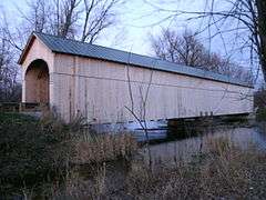
Cedar Swamp Covered Bridge
|
Cedar Swamp Covered Bridge | |
 | |
  | |
| Location | Swamp Creek Road over Otter Creek, between Cornwall and Salisbury, Vermont |
|---|---|
| Coordinates | 43°55′6″N 73°10′28″W / 43.91833°N 73.17444°WCoordinates: 43°55′6″N 73°10′28″W / 43.91833°N 73.17444°W |
| Area | 1 acre (0.40 ha) |
| Built | 1864 |
| Architectural style | Town lattice truss |
| NRHP Reference # | 74000386[1] |
| Added to NRHP | September 10, 1974 |
The Cedar Swamp Covered Bridge, also known as the Station Bridge and by various other names, was a historic wooden covered bridge spanning Otter Creek between Cornwall and Salisbury, Vermont. The Town lattice truss bridge was built in 1864-1865 and added to the National Register of Historic Places in 1974.[1] It was destroyed by fire in September 2016.
Description and history
The Cedar Swamp Covered Bridge stood in a rural area of southeastern Cornwall and western Salisbury, connecting Cornwall's Swamp Road with Salisbury's Creek Road. The bridge was a Town lattice truss structure, built as a single span 153.5 feet (46.8 m) long. It rested on abutments of marble that had were faced in concrete, and was supported near its center by a concrete pier added in 1969. The bridge was 18.5 feet (5.6 m) wide, with a roadway width of 14 feet (4.3 m) (one lane). Its exterior was finished in vertical board siding, which extended a short way on the inside of each portal. The portal openings were shaped as elliptical arches, and it was capped by a metal roof.[2]
Built in 1864-65, the bridge was one of Vermont's few covered bridges which spanned town lines, and was the only surviving 19th-century covered bridge in both Cornwall and Salisbury.[2] Refurbished in 2007-2008, the bridge was severely damaged by fire on September 10, 2016.[3][4]
See also
- National Register of Historic Places listings in Addison County, Vermont
- List of Vermont covered bridges
- List of bridges on the National Register of Historic Places in Vermont
References
- 1 2 National Park Service (2009-03-13). "National Register Information System". National Register of Historic Places. National Park Service.
- 1 2 Hugh Henry (1974). "NRHP nomination for Cedar Swamp Covered Bridge" (PDF). National Park Service. Retrieved 2016-09-27. with photos from 1974
- ↑ "Covered bridge fire believed to be suspicious". WPTZ. September 10, 2016. Retrieved 2016-09-10.
- ↑ McCright, John S. (10 September 2016). "Covered Bridge between Cornwall and Salisbury burns". Addison County Independant. Middlebury, VT: Addison Independent. Retrieved 12 September 2016.