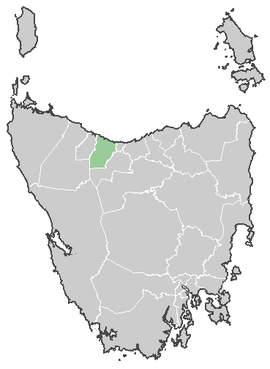
Central Coast Council, Tasmania
| Central Coast Council Tasmania | |||||||||||||
|---|---|---|---|---|---|---|---|---|---|---|---|---|---|
 Central Coast Council | |||||||||||||
| Coordinates | 41°16′33″S 146°2′46″E / 41.27583°S 146.04611°ECoordinates: 41°16′33″S 146°2′46″E / 41.27583°S 146.04611°E | ||||||||||||
| Population | 21,747 (2010)[1] | ||||||||||||
| • Density | 23.3562/km2 (60.492/sq mi) | ||||||||||||
| Area | 931.1 km2 (359.5 sq mi) | ||||||||||||
| Mayor | Jan Bonde | ||||||||||||
| Council seat | Central Coast, Tasmania | ||||||||||||
| Region | Ulverstone and Penguin area | ||||||||||||
| State electorate(s) | Braddon | ||||||||||||
| Federal Division(s) | Braddon | ||||||||||||
 | |||||||||||||
The Central Coast Council is a local government area of Tasmania, Australia on the north-west coast of the state, between the cities of Devonport and Burnie.
The municipality contains two major centres Ulverstone and Penguin, smaller towns include Forth, and Turners Beach.
The Central Coast includes the tourist destinations Leven Canyon[2] and Black Bluff,[3] as well as a number of rural areas such as Upper Castra.
The Central Coast Council was created on 2 April 1993, and covers an area of 932 square kilometres (360 sq mi). The municipal boundaries are the Blythe River in the west, Braddons Lookout Road in the east and Black Bluff in the south.[4]
TFR for Central Coast Council was estimated at 1.92 in 2001 and 2.28 in 2006.
Government
| Name | Position[5] | Party affiliation | |
|---|---|---|---|
| Jan Bonde | Mayor/Councillor | Independent | |
| Kathleen Downie | Deputy Mayor/Councillor | Independent | |
| John Bloomfield | Councillor | Independent | |
| Shane Broad | Councillor | Independent | |
| Garry Carpenter | Councillor | Independent | |
| Gerry Howard | Councillor | Independent | |
| Rowen Tongs | Councillor | Independent | |
| Tony van Rooyen | Councillor | Independent | |
| Phillip Viney | Councillor | Independent | |
Suburbs[6]
| Suburb | Census Population 2011 | Reason |
|---|---|---|
| Blthye Heads | Incl. in Heybridge | |
| Heybridge | 507 | Includes Blythe Heads, Howth, Sulphur Creek |
| Howth | Incl. in Heybridge | |
| Sulphur Creek | Incl. in Heybridge | |
| Preservation Bay | Incl. in Penguin | |
| Penguin | 3924 | Includes Preservation Bay, Carmantown |
| Cuprona | 308 | Includes West Pine, Carmena |
| West Pine | Incl. in Cuprona | |
| Carmantown | Incl. in Penguin | |
| West Ulverstone | 4337 | |
| Ulverstone | 6343 | |
| Turners Beach | 1595 | |
| Carmena | Incl. in Cuprona | |
| Leith | 434 | |
| Forth | 1,024 | Includes Forthside (Devonport), Melrose (Devonport) and Paloona (Devonport) |
| Kindred | 417 | Includes Sprent |
| Upper Castra | 122 | Includes Castra |
| Castra | Incl. in Upper Castra | |
| Nietta | Incl. in Preston | |
| South Nietta | Incl. in Preston | |
| South Preston | Incl. in Preston | |
| Preston | 250 | Includes Nietta, South Nietta, South Preston, Loongana, Warringa |
| Loongana | Incl. in Preston | |
| Loyetea | Incl. in South Riana | |
| Heka | Incl. in South Riana | |
| Warringa | Incl. in Preston | |
| Gunns Plains | Incl. in South Riana | |
| Riana | 325 | |
| South Riana | 449 | Includes Loyetea, Heka, Gunns Plains |
| Sprent | Incl. in Kindred | |
| Spalford | Incl. in Gawler | |
| Abbotsham | Incl. in Gawler | |
| Gawler | 792 | Includes Spalford, Abbotsham |
| North Motton | 398 | |
| Total | 21,225 | |
| 130 | Variance | |
| Local Government Total | 21,355 | Gazetted Central Coast Local Government Area |
References
- ↑ Australian Bureau of Statistics (31 March 2011). "3218.0 - Regional Population Growth, Australia, 2009-10". Retrieved 23 August 2011. Estimated resident population (ERP) at 30 June 2010.
- ↑ Leven Canyon
- ↑ Black Bluff
- ↑ Central Coast Council - Annual Report 2002-2003
- ↑ "Councillors - Central Coast Council". centralcoast.tas.gov.au. Central Coast Council. Retrieved 1 February 2015.
- ↑ Australian Bureau of Statistics. "2011 Census QuickStats". Retrieved 2 April 2016.
External links
This article is issued from Wikipedia - version of the 11/27/2016. The text is available under the Creative Commons Attribution/Share Alike but additional terms may apply for the media files.