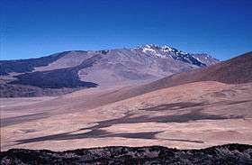
Cerro El Cóndor
| Cerro El Cóndor | |
|---|---|
 Cerro El Cóndor from the east | |
| Highest point | |
| Elevation | 6,414 m (21,043 ft) [1] |
| Prominence | 1,660 m (5,450 ft) [1] |
| Listing | Ultra |
| Coordinates | 26°37′54″S 68°21′42″W / 26.63167°S 68.36167°WCoordinates: 26°37′54″S 68°21′42″W / 26.63167°S 68.36167°W [1] |
| Geography | |
 Cerro El Cóndor Argentina | |
| Location | Argentina |
| Parent range | Andes |
| Geology | |
| Age of rock | Holocene |
| Mountain type | Stratovolcano |
| Climbing | |
| First ascent | Alexander von Götz, Steffen Salzmann, et al., 2003 |
Cerro El Cóndor is a stratovolcano in Argentina. It is a remote peak in the Argentine Puna de Atacama. As such it was probably the last major 6000m+ peak in the Andes to be climbed,[2] the first recorded ascent being in 2003 by Alexander von Götz and Steffen Salzmann of Germany.
See also
- List of volcanoes in Argentina
- List of mountains in Argentina
- List of mountains in the Andes
- List of Ultras of South America
References
- 1 2 3 "Argentina and Chile North: Ultra-Prominences" Peaklist.org. Retrieved 2013-02-25.
- ↑ Biggar, John (2005). The Andes: A Guide for Climbers (3rd ed.). Andes Publishing (Scotland). p. 304 pp. ISBN 0-9536087-2-7.
Sources
- Siebert L, Simkin T (2002-). Volcanoes of the World: an Illustrated Catalog of Holocene Volcanoes and their Eruptions. Smithsonian Institution, Global Volcanism Program Digital Information Series, GVP-3, (http://www.volcano.si.edu).
External links
This article is issued from Wikipedia - version of the 10/31/2016. The text is available under the Creative Commons Attribution/Share Alike but additional terms may apply for the media files.