Chester Center Historic District
|
Chester Center Historic District | |
|
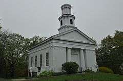
The Congregational Church in Chester Center | |
  | |
| Location | Chester, Massachusetts |
|---|---|
| Coordinates | 42°17′26″N 72°55′27″W / 42.29056°N 72.92417°WCoordinates: 42°17′26″N 72°55′27″W / 42.29056°N 72.92417°W |
| Architect | Sykes,Henry A. |
| Architectural style | Greek Revival, Colonial, Federal |
| NRHP Reference # | [1] |
| Added to NRHP | February 25, 1988 |
The Chester Center Historic District is a historic district encompassing the historic center of Chester, Massachusetts. The area was first laid out by Chester's first settlers in 1763. It remained the center of commerce and civic life in the rural agricultural community until railroads were built in other areas of the town in the 1840s. The village center declined in importance as economic activity moved to areas more readily accessible to the railroad, and the town hall was eventually moved to Chester Factories.[2] The district includes properties on Skyline Trail near the intersection of Bromley and Lyman Roads, and features Greek Revival, colonial, and Federal architecture. It was listed on the National Register of Historic Places in 1988.[1]
See also
- National Register of Historic Places listings in Hampden County, Massachusetts
- North Chester Historic District
References
- 1 2 National Park Service (2008-04-15). "National Register Information System". National Register of Historic Places. National Park Service.
- ↑ "MACRIS inventory record for Chester Center Historic District". Commonwealth of Massachusetts. Retrieved 2013-12-07.

