Chesterton railway station
| Chesterton | |
|---|---|
|
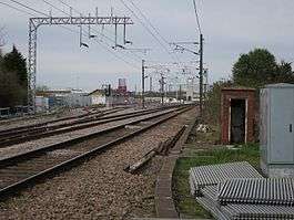
Station site in 2016. | |
| Location | |
| Place | Chesterton |
| Area | Cambridge |
| Coordinates | 52°13′19″N 0°09′26″E / 52.222°N 0.1573°ECoordinates: 52°13′19″N 0°09′26″E / 52.222°N 0.1573°E |
| Operations | |
| Original company | Eastern Counties Railway |
| History | |
| January 19, 1850 | Opened |
| October 1850 | Closed |
| Disused railway stations in the United Kingdom | |
|
Closed railway stations in Britain A B C D–F G H–J K–L M–O P–R S T–V W–Z | |
|
| |
Chesterton railway station was located on the line between Cambridge and Histon.[1] It opened in 1850 and closed the same year.
History
In 1846, the Eastern Counties Railway (ECR) obtained authorisation to construct the Wisbech, St Ives and Cambridge Junction Railway.[2] The section from St Ives to Chesterton Junction on the King's Lynn to Cambridge line opened on 17 August 1847.[3] The line was originally double-track but was singled by 1854 before being redoubled in the 1870s.[4]
The ECR opened a "flag station" at Chesterton Junction on 19 January 1850.[5] It remained open until October 1850.[6][5][7][8] It was situated on the north side of Fen Road just before the main line crossed the River Cam.[9] A signal box controlling the junction and level crossing over Fen Road stood at the northern end of the bridge until November 1984.[10]
A triangle of land between the St Ives branch and the main line was used at least from 1911 by the permanent way department to store materials and comprised a number of sidings.[11] A modern permanent way depot was built on the site after the Second World War which incorporated a long-welded rails plant and a 2 ft (610 mm) gauge system operated by Ruston and Hornsby diesel mechanical locomotives.[12] By 2005, the depot had been abandoned and the site was heavily overgrown.[13]
| Preceding station | Historical railways | Following station | ||
|---|---|---|---|---|
| Histon Line and station closed |
Eastern Counties Railway Wisbech, St Ives and Cambridge Jcn Rly |
Cambridge Line and station open | ||
| Waterbeach Line and station open |
Eastern Counties Railway King's Lynn to Cambridge |
|||
Present day
By 2008, the sidings at Chesterton Junction were in use by Lafarge which operated an aggregates storage facility, a concrete batching and coated roadstone plants.[14] In 2015, planning permission was granted for the redevelopment of part of Chesterton Sidings for the construction of Cambridge North railway station, which is expected to open in May 2017.[15] The remainder of the 18-hectare (44-acre) site will become part of a mixed-use development with office, residential and retail space, and involving the relocation of the existing freight facility.[16]
References
- ↑ Dewick, Tony (2002). Complete Atlas of Railway Station Names. Ian Allan. ISBN 0-7110-2798-6.
- ↑ Awdry, Christopher (1990). Encyclopaedia of British Railway Companies. Sparkford: Patrick Stephens Ltd. p. 171. ISBN 1-8526-0049-7. OCLC 19514063.
- ↑ Gordon, D.I. (1990) [1968]. The Eastern Counties. A Regional History of the Railways of Great Britain. 5. Newton Abbot: David St John Thomas. p. 153. ISBN 0-946537-55-0.
- ↑ Adderson, Richard; Kenworthy, Graham (October 2005). Cambridge to Ely including St Ives to Ely. Eastern Main Lines. Midhurst: Middleton Press. fig. XV. ISBN 978-1-904474-55-5.
- 1 2 Quick, Michael (2009) [2001]. Railway passenger stations in Great Britain: a chronology (4th ed.). Oxford: Railway and Canal Historical Society. p. 123. ISBN 978-0-901461-57-5. OCLC 612226077.
- ↑ Butt, R. V. J. (1995). The Directory of Railway Stations: details every public and private passenger station, halt, platform and stopping place, past and present (1st ed.). Sparkford: Patrick Stephens Ltd. p. 60. ISBN 1-8526-0508-1. OCLC 60251199.
- ↑ Adderson & Kenworthy (2005), fig. 90
- ↑ Clinker, C.R. (1988) [1978]. Clinker's Register of Closed Passenger Stations and Goods Depots in England, Scotland and Wales 1830–1980 (2nd ed.). Bristol: Avon-Anglia Publications & Services. p. 28. ISBN 0-905466-91-8. OCLC 655703233.
- ↑ Cobb, M.H. (2006) [2003]. The Railways of Great Britain: A Historical Atlas. 1. Shepperton: Ian Allan. p. 227. ISBN 978-0-7110-3236-1.
- ↑ Adderson & Kenworthy (2005), fig. 91
- ↑ Adderson & Kenworthy (2005), fig. 87
- ↑ Adderson & Kenworthy (2005), figs. 92 and 93
- ↑ Adderson & Kenworthy (2005), fig. 95
- ↑ Roger Tym and Partners (May 2008). "Cambridge Northern Fringe East - Viability of Planning Options" (PDF). para. 1.2. Retrieved 2016-12-01.
- ↑ ITV News (2016-01-22). "Cambridgeshire's new railway station hit by more delays". Retrieved 2016-11-29.
- ↑ Brookgate (2015-02-19). "Relocation of railway sidings at Chesterton enables delivery of CB4 development". Cambridge Network. Retrieved 2016-12-01.
