Chestnut Ridge (Laurel Highlands)

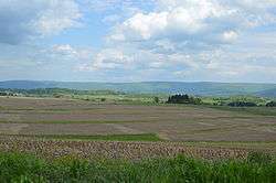
Fields south of Uniontown, with the western side of Chestnut Ridge in the background
Chestnut Ridge is the westernmost ridge in the Appalachian Mountains. It is located primarily within the Laurel Highlands region of southwestern Pennsylvania.
Geography
Chestnut Ridge rises in southern Indiana County and continues south-west-southwardly for 75 miles. The ridge crosses into West Virginia then gradually slopes down and finally ends 10 miles (16 km) southeast of Morgantown, West Virginia.
The ridge passes near the cities of: Blairsville, Derry, Latrobe, Mt. Pleasant, Connellsville, and Uniontown in Pennsylvania; and Morgantown in West Virginia.
External links
| Wikimedia Commons has media related to Chestnut Ridge (Laurel Highlands). |
Coordinates: 40°14′00″N 79°21′59″W / 40.23333°N 79.36639°W
This article is issued from Wikipedia - version of the 8/9/2016. The text is available under the Creative Commons Attribution/Share Alike but additional terms may apply for the media files.