Chile Route 27

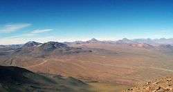
Chile Route 27 and other secondary roads as seen from Licancabur volcano.
Chile Route 27 (Ruta 27 CH) is a main road in the northern portion of Chile. It runs 156.19 km (97.05 mi)[1] from San Pedro de Atacama to Paso de Jama. A short road off Route 27 heads north to Portezuelo del Cajón. Another adjacent road leads to Llano de Chajnantor Observatory. The Route 27 reaches an altitude of 4,810 m (15,780 ft) 100 km west of the border.[2]
The sections Salar de Pujsa and Salar de Tara-Salar de Aguas Calientes of Los Flamencos National Reserve can be accessed by this road.
References
- ↑ "Dimensionamiento y Características de la Red Vial Nacional" (in Spanish). Dirección de Vialidad del Ministerio de Obras Públicas de Chile. Retrieved 20 April 2012.
- ↑ Google maps, terrain mode
This article is issued from Wikipedia - version of the 11/8/2016. The text is available under the Creative Commons Attribution/Share Alike but additional terms may apply for the media files.