Chincha Alta
| Chincha Alta | |
|---|---|
| Town | |
|
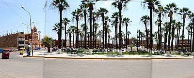
Panorama of the city center | |
| Nickname(s): "Cuna de campeones" (Cradle of Champions) | |
 Chincha Alta Location of the city of Chinca Alta in Peru | |
| Coordinates: 13°27′S 76°08′W / 13.450°S 76.133°W | |
| Country |
|
| Region | Ica |
| Province | Chincha |
| Government | |
| • Mayor | Lucio Juarez |
| Area | |
| • Total | 2,988 km2 (1,154 sq mi) |
| Elevation | 97 m (318 ft) |
| Population | |
| • Estimate (2015)[1] | 177,219 |
| Demonym(s) | Chinchano(a) |
| Time zone | PET (UTC-5) |
| • Summer (DST) | PET (UTC-5) |
| Website | www.munichincha.gob.pe |
Chincha Alta is a Peruvian city located in the Ica Region. It is the capital of Chincha Province.
Location
The City of Chincha Alta is located 200 kilometers south of Lima, in the Chincha Province of the Ica Region of Peru. The city covers an area of 2988 km² and has a population of 56,085.[2]
History
Pre-Chincha era
The first inhabitants of the area arrived at the beginning of the ninth century. These people are known as the "Pre-Chincha". The historian Luis Cánepa Pachas puts the date of the arrival of the Pre-Chincha at sometime in the tenth century. The rudimentary Pre-Chincha culture was centered on fishing and shell gathering. The origin of the Pre-Chincha people is still uncertain.
Chincha era
In the eleventh century, a more advanced and warlike people known as the Chincha arrived in the coastal area. The Chincha had developed systems of architecture, agriculture and irrigation. The Chincha came to dominate the original inhabitants of the area. Some aspects of the original Pre-Chincha culture were absorbed by the newcomers. The word Chincha is derived from "Chinchay" or "Chinchas" or "Cinca" which mean "jaguar" in Chincha Quechua. The Chincha worshiped a jaguar god, and believed themselves to be descended from jaguars, who gave them their warlike and dominating tendencies. The Chincha fertilized their fields with dead birds and guano, and this knowledge was passed on to later peoples. The Chincha learned seafaring skills from the Pre-Chincha, and may have traveled as far as Central America by boat.
Inca era
Between 1458 and 1460, the Chincha were conquered by the armies of the Inca Empire led by Tupac Inca Yupanqui during the reign of his father, Pachacuti. The Chincha area became an important part of the Inca Empire, and the Inca valued the Chincha for their agricultural knowledge and military skill. The Chincha region was then conquered by the Spanish, and the people of the region began to mix with Africans brought by the Spanish.
Modern era
In the early 19th Century, Chincha was known to British mariners as "Chinka". In late 1806, the British privateers Port au Prince and Lucy collaborated in capturing some Spanish vessels off the coast there and engaged in some inconclusive battles with the Spanish frigate Astraea.
The Chincha Islands, which are off the coast of Peru near Chincha and Pisco, were the focal point of the Chincha Islands War between Peru and Spain between 1864 and 1866.
2007 earthquake
The city, along with others near the Pacific coast, was damaged during the 2007 Peru earthquake.
Culture
African art and music

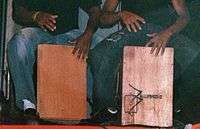
Afro-Peruvian culture has thrived in Chincha Alta, and the Afro-Peruvian residents of El Carmen district practice many traditional dances. The use of the Cajón drum, maracas and other traditional instruments figure prominently in Afro-Peruvian music, which is popular throughout the region. Traditional dances are performed during the Christmas season.
Afro-Peruvian folk culture
During February the "Verano Negro" (literally "Black Summer") festival is held, celebrating Afro-Peruvian food, music, culture and dance. The cuisine of the Chincha Alta area is considered distinct from other parts of Peru, because of its African background.
Anthem
It was composed in 1984 by Mrs. Ana Maria del Solar and Manolo Andrade Avalos, creators of the music and lyrics respectively, and approved by Municipal Resolution No. 1440 on 30 October of the same year. It has a chorus and three verses which commend and exalt the beauty of the Chincha region as well as the courage and heroism of its people.
References
- ↑ Perú: Población estimada al 30 de junio y tasa de crecimiento de las ciudades capitales, por departamento, 2011 y 2015. Perú: Estimaciones y proyecciones de población total por sexo de las principales ciudades, 2012-2015 (Report). Instituto Nacional de Estadística e Informática. March 2012. Retrieved 2015-06-03.
- ↑ "Aspectos Metodológicos" (PDF). Migración Interna Reciente y el Sistema de Ciudades, 2002–2007 (in Spanish). cional de Estadística e Informática. Retrieved 14 June 2013.
Coordinates: 13°27′S 76°08′W / 13.450°S 76.133°W
