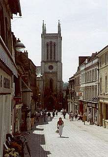
Church of St Michael the Greater, Stamford

The Church of St Michael the Greater is a late-Georgian Gothic church in Stamford, Lincolnshire which stands on the south side of Stamford High Street on the site of an earlier, Medieval predecessor.
It was called St Michael the Greater to distinguish it from another church, ‘St Michael in Cornstall’, situated elsewhere in Stamford.
History as a church
The site – at the heart of the Medieval town - suggests an early, perhaps even pre-Norman date for the foundation of the church but it is not until the middle of the twelfth century that it appears amongst property owned by Crowland Abbey. It is possible St Michael’s was originally founded by Crowland.[1] The Medieval church comprised a nave with north and south aisles and a chancel with north and south chapels and was a frequent meeting place in Medieval Stamford of ecclesiastical courts and corporation meetings.[2] It was extensively altered in the fifteenth century and again in the seventeenth at which time its western tower was made of wood, until 1761 when replaced in stone.[1] The church survived until 1832 when it collapsed after the Rector, the Rev. Charles Swann, removed a number of internal pillars from the nave apparently for aesthetic reasons.[3]
The current building, designed by John Brown of Norwich was built in Ketton stone over 1835-6 largely on all fours with the earlier church, in Early English style. It was based on the style of the Lady Chapel of Salisbury Cathedral and greatly applauded by the Stamford Mercury at the time.[3] It had a square west tower, iron railings around the perimeter of the site, substantial interior galleries “and elaborate pewing”.[4] The contractors were Woolston and Collins. The building’s original estimated cost, in 1834, was £2,800, while the final, total cost by the time of opening, in 1836, was £4,000.[5] Of the Medieval building, “no more than two re-used possibly thirteenth century stiff-leaf capitals [survive] in an undercroft beneath the west tower”.[6]
Decommission and conversion
The church was declared redundant in 1974 and after some years of vacillation when several options - including demolition – were considered[3] it was transformed into shops in 1982. The conversion, by Arthur Mull Associates of Huntingdon was described by Nikolaus Pevsner as “an unsympathetic use and an appalling conversion”.[6] but the Planning committee of South Kesteven District Council that authorised the conversion of this late-Georgian, Grade II listed building evidently thought otherwise. The interior was gutted and divided, and its Georgian plasterwork and stained glass windows destroyed. While a fifteenth-century font was dispatched to the Medieval church of St Nicholas, Leicester, a peal of eighteenth-century bells, a pair of seventeenth-century silver flagons and other church plate was apparently dispersed.[5]
Six plate-glass shop windows were introduced into the north wall, the shopping units extending to the ‘rear’ of the building on the ground floor while the remainder is used for storage. A car-park and delivery area were introduced at the rear, flattening much of the Medieval churchyard, although a number of fine eighteenth and nineteenth century tombstones and memorials, and in particular a late-seventeenth century chest tomb, survive. Even so, what little remains has also been threatened with development every few years, and a number of attempts made to build shop units upon it. These have, so far, been blocked.[3] The churchyard remains in the care of South Kesteven District Council.[7]
References
- 1 2 John S Hartley and Alan Rogers, The Religious Foundations of Medieval Stamford. Stamford Survey Group Report 2. University of Nottingham, 1974.
- ↑ Lincolnshire Record Society publications (various).
- 1 2 3 4 Martin Smith. Stamford Then & Now. Paul Watkins, 1992.
- ↑ Alan Rogers. The Book of Stamford. Barracuda, 1983.
- 1 2 Royal Commission on Historical Monuments. The Town of Stamford. London, 1977.
- 1 2 Nikolaus Pevsner and John Harris. The Buildings of England, Lincolnshire. Penguin, 1964.
- ↑ http://www.southkesteven.gov.uk/index.aspx?articleid=1870
Coordinates: 52°39′09″N 0°28′40″W / 52.6525°N 0.4778°W