Cirque de Gavarnie
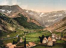
Photochrom circa 1900 of the Cirque de Gavarnie.
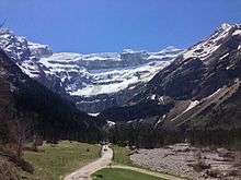
Snow Cirque de Gavarnie.
The Cirque de Gavarnie is a cirque in the central Pyrenees, in south-western France. The cirque is 800 m wide (on the deepest point) and about 3,000 m wide at the top. It is located within the commune of Gavarnie, the department of Hautes-Pyrénées, and the Pyrenees National Park.
Major features of the cirque are La Brèche de Roland and the Gavarnie Falls.

Village and cirque

Closer view of Gavarnie Falls
See also
External links
- Natura 2000 map
- Gavarnie panoramas (French)
| Wikimedia Commons has media related to Cirque de Gavarnie. |
Coordinates: 42°41′49″N 0°00′29″W / 42.69694°N 0.00806°W
This article is issued from Wikipedia - version of the 11/3/2016. The text is available under the Creative Commons Attribution/Share Alike but additional terms may apply for the media files.