Clackmannan (district)

From 1975, Clackmannan (from the Gaelic Clach Mhanainn, 'Stone of Manau') was the name of a small town and local government district in the Central region of Scotland, corresponding to the traditional county of Clackmannanshire, which was Scotland's smallest. The town of Clackmannan, in which the 'Stone' - a prehistoric monolith of probable cultic significance in the Iron Age - remains, was the chief settlement of its area from the Middle Ages (if not earlier), until supplanted from the second half of the 18th century by the growing manufacturing town of Alloa, on the north shore of the Firth of Forth. The medieval castle of Clackmannan Tower (Historic Scotland) stands above the town and is a landmark visible for many miles around. Dating from the 14th century, though much altered, the Tower is at present not open to the public, having been rendered dangerous by subsidence due to coal-mining (view from exterior).
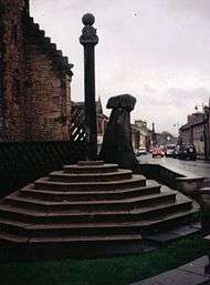
The Stone of Manau[1] stands by the mercat cross and the surviving tower and west gable of the former burgh tolbooth (built late 17th century) in the centre of the old town. Manau or Manaw was the name of the surrounding district in the Dark Ages.
The Local Government etc. (Scotland) Act 1994 transferred the name to a unitary authority with the same boundaries, but the authority has subsequently re-adopted the traditional name of Clackmannanshire.
Bruce family of Clackmannan
Sir Thomas Bruce 1st Baron of Clackmannan was a member of the House of Bruce and received lands in Clackmannan from his cousin Robert II
Archaeological Excavation
Headland Archaeology[2] has recently completed an excavation of a prehistoric and medieval site at Meadowend Farm, Kennet. The site, which lies to the south-east of Clackmannan, is within the corridor for the new road and bridge across the River Forth at Kincardine. Over 2000 fragments of prehistoric pottery were recovered from the site. The vast majority came from a dense concentration of pits or postholes and has been dated to the middle/late Neolithic. A small polished stone axe was found in the area of the Neolithic pit concentration. A larger unpolished axe (c.150 mm in length) was recovered from a pit elsewhere on site. The majority of the pottery consisted of fragments, but one near complete vessel was excavated. The pottery showed a wide variety of incised and impressed decoration. There was also a number of shallow hearths in the area but no clear contemporary structures were identified on site. At least 9 structures were identified on site. The most substantial of these was a large roundhouse with an outer ring-groove and an entrance to the south-east with an extended porch. Inside was a stone-lined hearth, and numerous pits and postholes. Many of these were rich in charcoal suggesting the structure may have burnt down. Prehistoric pottery has been recovered from the postholes dating to the middle/late Bronze Age. Two other ring-groove structures found on site were very heavily truncated. Two large post-built roundhouses were found, both with long porches, one with an entrance to the south-east, the other to the north-west. A third post-built structure contained a hearth-pit, which had been filled with fire-cracked stones and charcoal. It is hoped that radiocarbon dating will enable more precise phasing of the structures.
See also
References
External links
Coordinates: 56°10′N 3°45′W / 56.167°N 3.750°W