Colorado State Highway 95
| ||||
|---|---|---|---|---|
| Sheridan Boulevard | ||||
|
Map of north central Colorado with SH 95 highlighted in red | ||||
| Route information | ||||
| Maintained by CDOT | ||||
| Length: | 14.33 mi[1] (23.06 km) | |||
| Major junctions | ||||
| South end: |
| |||
| North end: |
| |||
| Location | ||||
| Counties: | Denver, Jefferson, Adams | |||
| Highway system | ||||
|
Colorado State Highways
| ||||

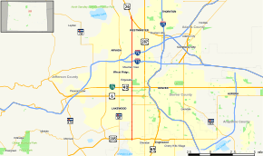
State Highway 95 is a 14.33 mile (23.06 km) long north–south state highway in the U.S. state of Colorado.
Route description
The route, also known as Sheridan Boulevard, starts at US 285 in Denver and ends at US 36 in Westminster. There are interchanges with US 6, I-70, and I-76. In the area between I-70 and Colfax Avenue, the road lies just west of Sloan's Lake. State Highway 95 is generally considered to be the dividing line between Jefferson County on the west and Denver and Adams counties on the east.
Major intersections
| County | Location | mi | km | Destinations | Notes |
|---|---|---|---|---|---|
| City and County of Denver | 0.000 | 0.000 | Interchange; southern terminus | ||
| Jefferson | | 3.975 | 6.397 | Western terminus of SH 26 | |
| | 5.018 | 8.076 | Interchange | ||
| Lakewood | 6.031 | 9.706 | |||
| Lakeside | 9.013 | 14.505 | Exit 271A on I-70 | ||
| | 9.889 | 15.915 | Exit 1B on I-76 | ||
| Adams | Westminster | 14.376 | 23.136 | Interchange; northern terminus | |
| 1.000 mi = 1.609 km; 1.000 km = 0.621 mi | |||||
References
- ↑ "Segment list for SH 95". Retrieved 2007-05-12.
External links
This article is issued from Wikipedia - version of the 10/9/2016. The text is available under the Creative Commons Attribution/Share Alike but additional terms may apply for the media files.