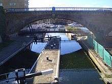
Commercial Road Lock
 Commercial Road Lock, 2008 | |
| Waterway | Regent's Canal |
|---|---|
| County |
Tower Hamlets Greater London |
| Maintained by | Canal & River Trust |
| Fall | 8 feet (2.4 m) |
| Distance to Limehouse Basin | 0.13 miles (0.21 km) |
| Distance to Paddington Basin | 8.8 miles (14.2 km) |
| Coordinates | 51°30′45″N 0°02′12″W / 51.512362°N 0.036607°WCoordinates: 51°30′45″N 0°02′12″W / 51.512362°N 0.036607°W |
Commercial Road Lock is a lock on the Regent's Canal in the London Borough of Tower Hamlets. It marks the point at which the canal enters Limehouse Basin, and is the penultimate lock before the canal reaches the Thames.
The nearest Docklands Light Railway station is Limehouse.
Gallery
-

Commercial Road Lock on the Regent's Canal entering the Limehouse Basin
See also
| Next lock upstream | Regent's Canal | Next lock downstream |
| Salmon Lane Lock No. 11 |
Commercial Road Lock Grid reference: TQ363810 |
Limehouse Lock No. 13 |
References
This article is issued from Wikipedia - version of the 11/4/2016. The text is available under the Creative Commons Attribution/Share Alike but additional terms may apply for the media files.