U.S. Route 20 in Oregon
| ||||
|---|---|---|---|---|
 | ||||
| Route information | ||||
| Maintained by ODOT | ||||
| Length: | 451.25 mi[1] (726.22 km) | |||
| Major junctions | ||||
| West end: |
| |||
| East end: | Idaho state line | |||
| Location | ||||
| Counties: | Lincoln, Benton, Deschutes, Linn, Harney, & Malheur | |||
| Highway system | ||||
| ||||

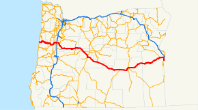
U.S. Route 20 (US 20) is a major west–east cross-state highway in the northern part of the U.S. state of Oregon, especially east of the Cascade Mountains. It connects U.S. Route 101 in Newport on the central Oregon Coast to the Idaho state line east of Nyssa.
Route description
US 20 starts at an intersection with US 101 in Newport, and travels eastward over the Central Oregon Coast Range to Corvallis. In Corvallis, it intersects Oregon Route 99W (OR 99W) and briefly travels concurrent with OR 34 before proceeding northeast to Albany. From Albany, US 20 briefly travels concurrent with OR 99E before turning east through Lebanon and Sweet Home and entering the Cascade Mountains. It intersects OR 126 west of Santiam Pass and the two routes travel concurrent through Sisters. US 20 then continues eastward and southward to Bend, where it travels concurrent with US 97 for about 5 miles (8.0 km) before turning east through Brothers and Riley. At Riley, US 20 travels concurrent with US 395 through Hines and Burns to about 2 miles (3.2 km) northeast of Burns. From Burns, US 20 continues east through Juntura and Vale. In Vale, US 20 travels concurrent with US 26, and the two highways continue east to Cairo Junction, south of Ontario, and turn south, where they then also travel concurrently with OR 201 to Nyssa. Eastward from Nyssa, US 20/US 26 continue to the Idaho state line.
Bannered routes
US 20 has 2 business routes in Oregon: one in Toledo, and one in Bend.
Future
Construction on a portion of US 20 between Newport and Corvallis, specifically, from just west of Chitwood to Eddyville, is being done to straighten and remove nearly 4.5 miles (7.2 km) from the route. The project will make it easier for larger vehicles to travel, provide greater passing opportunities and upgrade the highway to modern safety standards. Construction began in 2005, but was halted in 2007 because of excessive unexpected landslides. The project recommenced in May 2008 with a better plan for stabilizing these landslide locations. The final construction was expected to be completed in 2011, but continuing earth movement at four of the bridge sites delayed the project again. ODOT and the contractor were in a dispute over liability and money, a settlement was agreed upon, and the original design-build contract has been rescinded. ODOT assumed control of the project, and began completing the project in five phases. Because of the previous delays, completion of the project has been postponed until fall of 2016 for traffic on the road section, and late summer of 2017 for habitat improvement. The project is now estimated to cost $365.7 million.[2]
Oregon highway designations
The Oregon section of US 20 consists of the following highways (see Oregon highways and routes), from west to east:
- The Corvallis-Newport Highway No. 33;
- Part of the Corvallis-Lebanon Highway No. 210;
- The Albany-Corvallis Highway No. 31;
- The Santiam Highway No. 16;
- Part of the McKenzie Highway No. 15;
- The McKenzie-Bend Highway No. 17;
- Part of The Dalles-California Highway No. 4; and
- The Central Oregon Highway No. 7.
Major intersections
Milepoints are as reported by ODOT and do not necessarily reflect current mileage. Z indicates overlapping mileage due to construction longer than established route, and – indicates negative mileage behind established beginning point.[3] For routes traversing multiple named state highways, each milepoint is preceded by the corresponding state highway number.
| County | Location[4] | Milepoint[4] | Destinations | Notes | ||||
|---|---|---|---|---|---|---|---|---|
| Lincoln | Newport | 33 0.00 | ||||||
| | 33 5.62 | |||||||
| | 33 5.74 | |||||||
| | 33 7.49 | |||||||
| | 33 10.34 | Pioneer Mountain summit, elevation 377 feet (115 m) | ||||||
| | 33 23.18 | |||||||
| | 33 31.08 | Cline Hill summit, elevation 770 feet (230 m) | ||||||
| Benton | | 33 38.28 | Dudley Hill summit, elevation 860 feet (260 m) | |||||
| | 33 39.39 | |||||||
| | 33 41.78 | Gellately Hill summit, elevation 789 feet (240 m) | ||||||
| | 33 44.57 | |||||||
| | 33 49.73 | Western end of concurrency with OR 34 | ||||||
| Corvallis | 33 55.67 91 (2)84.07 | Interchange; eastern end of concurrency with OR 34; eastbound exit and westbound entrance | ||||||
| Interchange; western end of concurrency with OR 99W; westbound exit and eastbound entrance | ||||||||
| 91 (2)83.42 210 –0.05 | Eastern end of concurrency with OR 99W | |||||||
| 210 0.00 31 0.10 | ||||||||
| Benton–Linn county line | Albany | 31 10.44 | Willamette River | |||||
| Linn | 31 11.28 58 2.25 | Western end of concurrency with OR 99E | ||||||
| 58 (2)1.45 16 –0.03 | Eastern end of concurrency with OR 99E; eastbound exit and westbound entrance | |||||||
| 16 1.04– 16 1.08 | Exit 233 on I-5 | |||||||
| | 16 6.55 | |||||||
| Lebanon | 16 12.80 | |||||||
| Sweet Home | 16 27.07 | |||||||
| 16 31.19 | Viewpoint (Foster Lake) | |||||||
| | 16 46.93 | Historical marker (Santiam Wagon Road) | ||||||
| | 16 63.64 | Tombstone Pass summit, elevation 4,236 feet (1,291 m) | ||||||
| | 16 71.52 | Western end of Route 126 concurrency | ||||||
| | 16 74.90 | |||||||
| Linn–Jefferson county line | | 16 80.77 | Santiam Pass summit, elevation 4,817 feet (1,468 m) | |||||
| Jefferson | | 16 84.57 | Viewpoint (Mount Washington) | |||||
| Deschutes | | 16 99.53 | Historical marker (Santiam Pass Road) | |||||
| Sisters | 16 100.12 15 Z92.03 | |||||||
| 15 93.07 17 0.00 | Eastern end of concurrency with OR 126 | |||||||
| | 17 9.09– 17 9.18 | Viewpoint | ||||||
| Bend | 17 18.51 | Interchange; western end of concurrency with US 97 Bus.; eastbound entrance from US 97 south; westbound entrance from US 97 north | ||||||
| 17 19.86 | Interchange; eastbound exit only | |||||||
| Interchange; westbound exit only | ||||||||
| 17 20.99 7 0.51 | Eastern end of concurrency with US 97 Bus. | |||||||
| | 7 19.95 | Historical marker (prehistoric river) | ||||||
| | 7 20.56 | Horse Ridge summit, elevation 4,291 feet (1,308 m) | ||||||
| | 7 35.65 | |||||||
| Lake |
No major junctions | |||||||
| Harney | | 7 103.03 | Historical marker (Bannock War) | |||||
| | 7 104.69 | Western end of concurrency with US 395 | ||||||
| Burns | 7 131.50 | |||||||
| | 7 134.29 | Eastern end of concurrency with US 395 | ||||||
| | 7 144.25 | Historical marker (Fort Harney) | ||||||
| | 7 155.09 | Historical marker (Great Basin) | ||||||
| | 7 160.79 | Stinkingwater Pass, elevation 4,848 feet (1,478 m) | ||||||
| | 7 177.54 | Drinkwater Pass, elevation 4,212 feet (1,284 m) | ||||||
| Malheur | | 7 232.99 | Vines Hill summit, elevation 2,886 feet (880 m) | |||||
| | 7 238.78 | Graham Boulevard (OR 451) – Bully Creek Reservoir | ||||||
| Vale | 7 245.46 | Graham Boulevard (OR 451) | ||||||
| 7 246.39 | Western end of concurrency with US 26 | |||||||
| | 7 253.48 | Viewpoint (Trenkel Hill vista) | ||||||
| Cairo Junction | 7 258.20 | Western end of concurrency with OR 201 | ||||||
| Nyssa | 7 265.97 | Eastern end of Route 201 concurrency | ||||||
| 7 266.82 | Continuation into Idaho across Snake River | |||||||
1.000 mi = 1.609 km; 1.000 km = 0.621 mi
| ||||||||
See also
-
 Oregon portal
 -
 U.S. Roads portal
References
- ↑ "US Route 20 in Oregon".
- ↑ "The US 20 Project Background and History". Oregon Department of Transportation. Retrieved 11 May 2016.
- ↑ Road Inventory and Classification Services Unit. "Straightline Chart Legend" (PDF). Transportation Development Division, Oregon Department of Transportation. Retrieved August 29, 2015.
- 1 2 Road Inventory and Classification Services Unit. "Straightline Charts". Transportation Development Division, Oregon Department of Transportation. Retrieved September 22, 2016.
- Corvallis–Newport Highway No. 33 (September 2013)
- Pacific Highway West Highway No. 1W(91) (July 2014)
- Corvallis–Lebanon Highway No. 210 (November 2011)
- Albany–Corvallis Highway No. 31 (February 2012)
- Albany–Junction City Highway No. 58 (March 2016)
- Santiam Highway No. 16 (August 2015)
- McKenzie Highway No. 15 (December 2011)
- McKenzie–Bend Highway No. 17 (November 2014)
- Central Oregon Highway No. 7 (July 2015)
External links
-
 Media related to U.S. Route 20 in Oregon at Wikimedia Commons
 - U.S. 20: Route crosses the Cascades and heads east - The Oregonian
| Previous state: Terminus |
Oregon | Next state: Idaho |