Creetown
Coordinates: 54°54′00″N 4°23′00″W / 54.9°N 4.383333°W
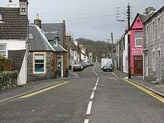
Creetown is a small seaport town in the Stewartry of Kirkcudbright, which forms part of the Galloway in the Dumfries and Galloway council area in south-west Scotland. Its population is about 750 people. It is situated near the head of Wigtown Bay, 18 miles (29 km) west of Castle Douglas. The town was originally named Ferrytown of Cree (Scottish Gaelic: Port Aiseig a' Chrìch) as it formed one end of a ferry route that took pilgrims across the River Cree estuary to the shrine of St Ninian at Whithorn. This is the reason why the local football team, formed in 1895, are known as 'The Ferrytoun'.
Creetown was formerly served by the Portpatrick and Wigtownshire Railway. The granite quarries in the vicinity constitute the leading industry, the stone for the Liverpool docks and other public works having been obtained from them.[1] The village dates from 1785, and became a burgh of barony in 1792. Sir Walter Scott laid part of the scene of Guy Mannering in this neighborhood. Dr Thomas Brown, the metaphysician (1778–1820), was a native of the parish in which Creetown lies.
Creetown Heritage Centre
The Creetown Heritage Museum is a community-based resource detailing and recording the cultural, industrial and natural history of Creetown and the surrounding area. It is run by a small volunteer committee who are constantly seeking to add to the collections of photographs, tools and artifacts from current and past village life.
Another ongoing project is the Oral History Project. Senior members of the community have been invited to relate their memories of Creetown during their lifetimes. The project has become a vital source of information and will be collated and documented for the future as a living reference to Creetown over the last 70 years.

Balloch Wood Community Project
The Balloch Wood Community Project arose from an approach by Forestry Commission Scotland in 2001 to develop Balloch Wood as a community asset. Over the following three years a great deal has been achieved. The first of several new paths have been opened, which will eventually lead to a new network of walks extending outwards into the surrounding hills from the village.
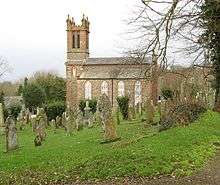
The new paths start less than 200m from Kirkmabreck Church and follow the Balloch Burn to the Mid Burn and then back down the centre of the woodland to the entrance. These paths have been added to by a new link path through the ancient woodland to the completed Curling Pond wildlife area. It is planned that a further path along the burnside to the Balloch Bridge will be developed in time to create a circular route.
At the Curling Pond, an all-abilities path has been constructed around and, between the ponds, a small car park has also been completed for the use of the less able.
It is hoped that local schools and other groups will use the ancient woodland as an open classroom to the benefit of the young people of the area. There is also the intention to introduce woodland sculptures and other significant artistic works which anyone can offer to be involved in.
References
- ↑ "Kirkmabreck Quarry – The History". Creetown Website. Retrieved 29 March 2015.
External links
- Detailed information on Creetown
- Balloch Wood Community Project
- Creetown Heritage Centre
- Curling Pond
![]() This article incorporates text from a publication now in the public domain: Chisholm, Hugh, ed. (1911). "article name needed". Encyclopædia Britannica (11th ed.). Cambridge University Press.
This article incorporates text from a publication now in the public domain: Chisholm, Hugh, ed. (1911). "article name needed". Encyclopædia Britannica (11th ed.). Cambridge University Press.

