Danks Down and Truckle Hill
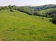
Danks Down, showing a footpath (part of the Macmillan Way) on the left and By Brook in the valley to the right. Long Dean Hamlet in middle-distance.
Danks Down and Truckle Hill (grid reference ST834758) is a 13.1 hectare biological Site of Special Scientific Interest in Wiltshire, notified in 1990.
Sources
- English Nature citation sheet for the site (accessed 16 August 2006)
External links
- English Nature website (SSSI information)
Coordinates: 51°28′52″N 2°14′23″W / 51.481°N 2.2397°W
This article is issued from Wikipedia - version of the 7/31/2016. The text is available under the Creative Commons Attribution/Share Alike but additional terms may apply for the media files.