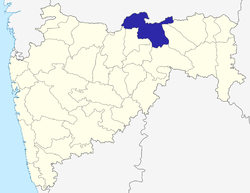
Dattapur Dhamangaon
| Dattapur-Dhamangaon Railway दत्तापुर धामणगांव | |
|---|---|
| city | |
 Dattapur-Dhamangaon Railway Location in Maharashtra, India | |
| Coordinates: 20°46′00″N 78°10′00″E / 20.7667°N 78.1667°ECoordinates: 20°46′00″N 78°10′00″E / 20.7667°N 78.1667°E | |
| Country |
|
| State | Maharashtra |
| District | Amravati |
| Elevation | 291 m (955 ft) |
| Population (2011) | |
| • Total | 22,430 |
| Languages | |
| • Official | Marathi |
| Time zone | IST (UTC+5:30) |
| PIN | 444709 |
| Telephone code | 07222 |
| Vehicle registration | MH-27 |
| Sex ratio | 51:49 ♂/♀ |
Dhamangaon is a city and a municipal council in Amravati district in the state of Maharashtra, India. Dhamangaon is one of the three talukas (Other two are Chandur Railway and Nandgaon Khandeshwar) in Chandur (Railway) subdivision in Amravati district. The municipal council is named as Dattapur-Dhamangaon Municipal council.[1]
Demographics
As of 2011 India census,[2] Dhamangaon had a population of 22,430. Males constitute 51% of the population and females 49%. Dhamangaon has an average literacy rate of 85%, higher than the national average of 59.5%: male literacy is 83% and, female literacy is 88%. In Dhamangaon, 12% of the population is under 6 years of age.
Geography
It is located at 300 meters above the sea level. It is at south-east region in Amravati district. Dhamangaon is surrounded by Chandur Railway taluka at West, Tivasa taluka in north from Amravati district, Babhulgaon Taluka of Yavatmal district at south and Arvi and Deoli talukas from Wardha district in the east.[3]
Climate
Dhamangaon has a tropical climate with hot, dry summers and mild to cool winters. Summer lasts from March to June, monsoon season from July to October and winter from November to March. The warmest month is May. About 979 mm of precipitation falls annually.[4]
Governance
Dattapur-Dhamangaon is a Municipal Council is the local authority in the city. The Dattapur-Dhamangaon city is divided into 17 wards for which elections are held every 5 years.[5]
Professions
Out of total population, 7,174 were engaged in work or business activity. Of this 5,690 were males while 1,484 were females. Of total 7174 working population, 89.27% were engaged in Main Work while 10.73% of total workers were engaged in Marginal Work. This region mostly depends on the cotton & agricultural business.[6]
Transport
Dhamangaon is well connected by road and trains to other important cities. Dhamangaon railway station is a railway station serving Dhamangaon town, in Amravati district of Maharashtra State of India. It is under Nagpur railway division of Central Railway Zone of Indian Railways. It is located on Howrah–Nagpur–Mumbai line of the Indian Railways. As of 2016, electrified double Broad Gauge railway line exist and at this station, 40 trains stops. Dr. Babasaheb Ambedkar International Airport (Nagpur), is at distance of 105 kilometers.
References
- ↑ http://amravati.nic.in/htmldocs/demographic.html
- ↑ "Census of India 2001: Data from the 2001 Census, including cities, villages and towns (Provisional)". Census Commission of India. Archived from the original on 2004-06-16. Retrieved 2008-11-01.
- ↑ https://www.google.co.in/search?q=maps+of+amravati+district&espv=2&source=lnms&tbm=isch&sa=X&ved=0ahUKEwiMoJKp3J3MAhVENqYKHQthA0IQ_AUICCgC&biw=1280&bih=653#imgrc=_
- ↑ http://en.climate-data.org/location/173466/
- ↑ http://www.census2011.co.in/data/town/802693-dattapur-dhamangaon-maharashtra.html
- ↑ http://www.census2011.co.in/data/town/802693-dattapur-dhamangaon-maharashtra.html
