Delyan Point
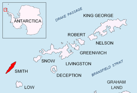
Location of Smith Island in the South Shetland Islands.
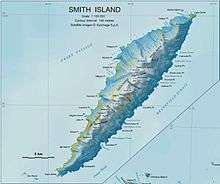
Topographic map of Smith Island.
Delyan Point (Bulgarian: нос Делян, ‘Nos Delyan’ \'nos de-'lyan\) is a point on the northwest coast of Smith Island, South Shetland Islands forming the northeast side of the entrance to Vedena Cove. Situated 4 km west-southwest of Cape Smith, 10.66 km northeast of Markeli Point and 1.4 km northwest of Matochina Peak. Bulgarian early mapping in 2009. Named after Peter Delyan – Czar Peter II of Bulgaria, 1040-1041 AD.
Coordinates: 62°52′49.8″S 62°22′49.5″W / 62.880500°S 62.380417°W
Maps
- L.L. Ivanov. Antarctica: Livingston Island and Greenwich, Robert, Snow and Smith Islands. Scale 1:120000 topographic map. Troyan: Manfred Wörner Foundation, 2009. ISBN 978-954-92032-6-4
References
- SCAR Composite Antarctic Gazetteer
- Bulgarian Antarctic Gazetteer. Antarctic Place-names Commission of Bulgaria.
This article includes information from the Antarctic Place-names Commission of Bulgaria which is used with permission.
This article is issued from Wikipedia - version of the 11/14/2016. The text is available under the Creative Commons Attribution/Share Alike but additional terms may apply for the media files.