Denmark Sound
| Denmark Sound Denmark Fjord | |
|---|---|
 Location | |
| Location | Arctic |
| Coordinates | 81°40′N 26°20′W / 81.667°N 26.333°WCoordinates: 81°40′N 26°20′W / 81.667°N 26.333°W |
| Ocean/sea sources | Wandel Sea |
| Basin countries | Greenland |
| Frozen | Practically all year round |
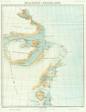
Denmark Sound or Denmark Fjord (Danish: Danmark fjord) is a fjord or sound located on the northeast tip of Greenland within Northeast Greenland National Park.
The fjord was found and named during the Denmark expedition 1906-1908 led by Lauge Koch which mapped Greenland's north coast between Cape York and Denmark Sound.[1]
Geography
This fjord, together with Independence Sound and Hagen Sound, flows into the Wandel Sea, which is part of the Arctic Ocean. Three islands are located in the bay at the mouth of the sound, Princess Thyra Island, Princess Margaret Island and Princess Dagmar Island.[2] The area was formerly part of Avannaa, originally Nordgrønland ("North Greenland"), a former county of Greenland until 31 December 2008.
The Danish military base/weather station Nord is located by the sound on the western side of Crown Prince Christian Land Peninsula.
 Map of Northeastern Greenland. |
 1911 German map of NE Greenland showing the Denmark Fjord. |
See also
References
- ↑ John McCannon, A History of the Arctic: Nature, Exploration and Exploitation, p. 213
- ↑ Prinsesse Thyra Ø