Dergalt
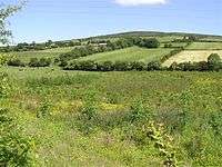
Dergalt townland in 2006
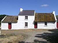
Wilson Homestead, Dergalt, 2006
Dergalt is a townland in County Tyrone, Northern Ireland. It is situated in the historic barony of Strabane Lower and the civil parish of Camus and covers an area of 488 acres.[1] US President Woodrow Wilson's ancestral home is located in the townland.
The name derives from the Irish: dearg alt (red glenside).[2]
The population of the townland declined during the 19th century:[3][4]
| Year | 1841 | 1851 | 1861 | 1871 | 1881 | 1891 |
|---|---|---|---|---|---|---|
| Population | 217 | 175 | 168 | 114 | 111 | 100 |
| Houses | 43 | 34 | 32 | 27 | 24 | 22 |
See also
| Wikimedia Commons has media related to Dergalt. |
References
- ↑ "Townlands of County Tyrone". IreAtlas Townland Database. Retrieved 19 March 2013.
- ↑ "Dergalt". Place Names NI. Retrieved 19 March 2013.
- ↑ "Census of Ireland 1851". Enhanced Parliamentary Papers on Ireland. Retrieved 19 March 2013.
- ↑ "Census of Ireland 1891". Enhanced Parliamentary Papers on Ireland. Retrieved 19 March 2013.
This article is issued from Wikipedia - version of the 6/22/2016. The text is available under the Creative Commons Attribution/Share Alike but additional terms may apply for the media files.